
Geographic Region: USA-CALIFORNIA
Feature: THICK SMOKE, LOS ANGELES
|
Geographic Region: USA-CALIFORNIA Feature: THICK SMOKE, LOS ANGELES |
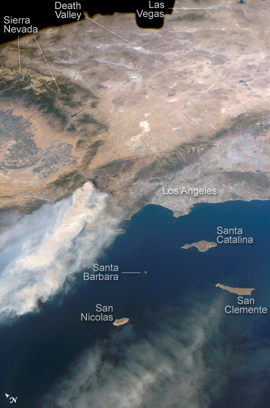 |
| Day Fire, Southern California: The Day Fire started in Los Padres National Forest north of Los Angeles on September 4, 2006. Easterly winds on September 17 blew the smoke westward, out to sea, and International Space Station astronauts observed this wind shift. In this astronaut photograph, the forested mountains north of Los Angeles appear dark green, and the smoke appears gray. Dense farmland appears at the south end of California's Central Valley. The extent of the Day Fire smoke plume can be gauged from the gray urban region of greater Los Angeles (image right, center), which stretches along 80 kilometers (50 miles) of coastline. The plume obscures the northern Channel Islands, but the southern Channel Islands are silhouetted against the ocean, in the foreground. In the days before and after this photo was taken, shifting winds moved the smoke in different directions. On September 17, the plume was caught by westerly winds that steered the smoke back towards California--the leading edge of the gray smoke can be seen heading towards San Clemente Island. |
| Images: | All Available Images Low-Resolution 414k |
|
| Mission: | ISS013 |
|
| Roll - Frame: | E - 81687 |
|
| Geographical Name: | USA-CALIFORNIA |
|
| Features: | THICK SMOKE, LOS ANGELES |
|
| Center Lat x Lon: | 34.5N x 118W |
|
| Film Exposure: | N=Normal exposure, U=Under exposed, O=Over exposed, F=out of Focus |
|
| Percentage of Cloud Cover-CLDP: | 10 |
|
| Camera:: | E4 |
|
| Camera Tilt: | 45 | LO=Low Oblique, HO=High Oblique, NV=Near Vertical |
| Camera Focal Length: | 28 |
|
| Nadir to Photo Center Direction: | NE | The direction from the nadir to the center point, N=North, S=South, E=East, W=West |
| Stereo?: | Y=Yes there is an adjacent picture of the same area, N=No there isn't |
|
| Orbit Number: | 779 |
|
| Date: | 20060917 | YYYYMMDD |
| Time: | 225236 | GMT HHMMSS |
| Nadir Lat: | 31.7N |
Latitude of suborbital point of spacecraft |
| Nadir Lon: | 119.4W |
Longitude of suborbital point of spacecraft |
| Sun Azimuth: | 244 | Clockwise angle in degrees from north to the sun measured at the nadir point |
| Space Craft Altitude: | 186 | nautical miles |
| Sun Elevation: | 38 | Angle in degrees between the horizon and the sun, measured at the nadir point |
| Land Views: | FOREST, ISLAND, VALLEY |
|
| Water Views: | OCEAN |
|
| Atmosphere Views: | PLUME, SMOKE |
|
| Man Made Views: | |
|
| City Views: | LOS ANGELES |
|
Photo is not associated with any sequences | ||
| NASA Home Page |
JSC Home Page |
JSC Digital Image Collection |
Earth Science & Remote Sensing |
|
This service is provided by the International Space Station program and the JSC Earth Science & Remote Sensing Unit, ARES Division, Exploration Integration Science Directorate.

|