Geographic Region: MONGOLIA
Feature: HAR LAKE, SPREADING DUNES
|
Geographic Region: MONGOLIA Feature: HAR LAKE, SPREADING DUNES |
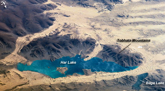 |
| ISS013-E-78506 (7 Sept. 2006) --- Sand dunes near Mongolia's Har Lake are featured in this image photographed by an Expedition 13 crewmember on the International Space Station. Har (or Black) Lake is located in the western part of the country within the Valley of Lakes--part of a system of closed basins that stretches across central Asia. According to scientists, these basins are the remnants of larger paleolakes that had begun to shrink in size by approximately five thousand years ago as regional climate became drier. Today, the Valley of Lakes is an important ecological resource for study of steppe grasslands, and as resting points for large numbers of migratory birds. Portions of the basin are designated as national parks or other protected areas, and Har Lake itself is an ecotourism destination (usually by horseback). This oblique view captures the dynamic nature of the landscape of Har Lake. The lake is encircled by sand dune fields which encroach on the lower slopes of the Tobhata Mountains to the west and south. Gaps in the mountains have been exploited by sand dunes moving eastward (indicating westerly winds) -- the most striking example being a series of dunes entering Har Lake along its southwestern shoreline. Here, the dune forms reflect the channeling of winds through the break in the mountain ridgeline, leading to dune crests oriented transverse to northwesterly winds. Another well-developed line of dunes is visible between Har and Baga Lakes. While these dunes appear to cut across a lake surface, the dunes have in fact moved across a narrow stream channel. |
| Images: | All Available Images Low-Resolution 249k |
|
| Mission: | ISS013 |
|
| Roll - Frame: | E - 78506 |
|
| Geographical Name: | MONGOLIA |
|
| Features: | HAR LAKE, SPREADING DUNES |
|
| Center Lat x Lon: | 48.3N x 96.1E |
|
| Film Exposure: | N=Normal exposure, U=Under exposed, O=Over exposed, F=out of Focus |
|
| Percentage of Cloud Cover-CLDP: | 10 |
|
| Camera:: | E4 |
|
| Camera Tilt: | HO | LO=Low Oblique, HO=High Oblique, NV=Near Vertical |
| Camera Focal Length: | 400 |
|
| Nadir to Photo Center Direction: | W | The direction from the nadir to the center point, N=North, S=South, E=East, W=West |
| Stereo?: | Y=Yes there is an adjacent picture of the same area, N=No there isn't |
|
| Orbit Number: | 612 |
|
| Date: | 20060907 | YYYYMMDD |
| Time: | 083026 | GMT HHMMSS |
| Nadir Lat: | 51.7N |
Latitude of suborbital point of spacecraft |
| Nadir Lon: | 104.3E |
Longitude of suborbital point of spacecraft |
| Sun Azimuth: | 242 | Clockwise angle in degrees from north to the sun measured at the nadir point |
| Space Craft Altitude: | 184 | nautical miles |
| Sun Elevation: | 27 | Angle in degrees between the horizon and the sun, measured at the nadir point |
| Land Views: | BASIN, DUNE, MOUNTAIN, VALLEY |
|
| Water Views: | CHANNEL, LAKE |
|
| Atmosphere Views: | |
|
| Man Made Views: | |
|
| City Views: | |
|
Photo is not associated with any sequences | ||
| NASA Home Page |
JSC Home Page |
JSC Digital Image Collection |
Earth Science & Remote Sensing |
|
This service is provided by the International Space Station program and the JSC Earth Science & Remote Sensing Unit, ARES Division, Exploration Integration Science Directorate.

|