
Geographic Region: RUSSIAN FEDERATION
Feature: W. VOLGA R. DELTA, SED. PLUMES
|
Geographic Region: RUSSIAN FEDERATION Feature: W. VOLGA R. DELTA, SED. PLUMES |
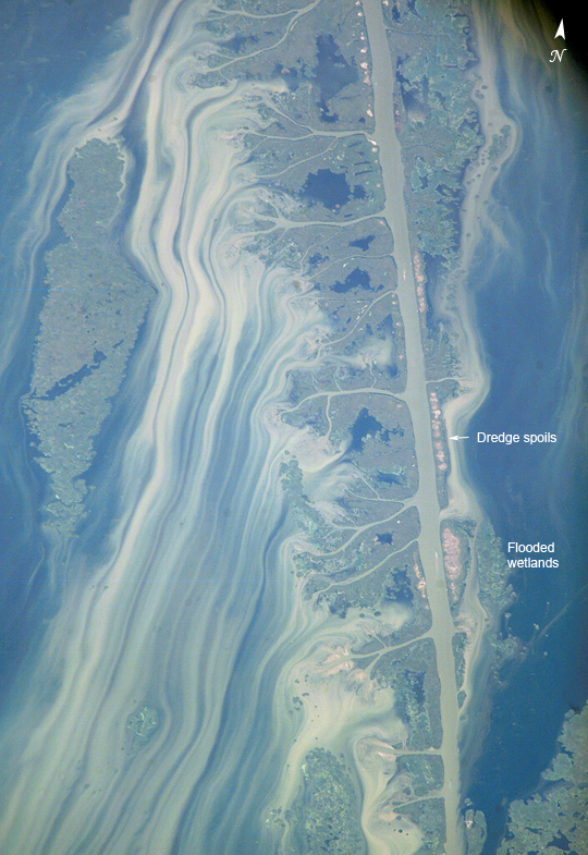 |
| Volga River Delta The Volga River drains much of western Russia's industrial region as it travels southward to empty into the Caspian Sea. Over thousands of years, the river has built a tremendous delta that forms the northwestern shoreline of the Caspian Sea. The delta channels provide transportation between the heartland of Russia and the oil-rich Caspian Sea. The Volga's extensive distributaries (branches to the sea) harbor habitat and rich fishing grounds for Russia's famous beluga sturgeon, the source of beluga caviar. The delta's wetlands, parts of which are designated as the Astrakhanskiy Biosphere Reserve, are important stopping points and breeding grounds for migrating water birds. This detailed astronaut photograph zooms in on a shipping channel in the western part of the delta. The straight channel is periodically dredged, and the dredged material is piled along the edge of the channel in mounds. Surrounding wetlands are partially inundated. Flood waters with muddy sediment stream from the distributaries along the channel, producing long streamers. This image was taken a few days after heavy rains in early September 2006 flooded parts of Russia to the north, and it captures the flood waters emptying into the Caspian Sea. Since 1978, the Caspian Sea level has risen over 2 meters (a little over 6 feet), submerging valuable wetland habitats, flooding coastlines, agricultural land, and industrial infrastructure. It has become a struggle for the nations surrounding the Caspian to maintain channels and coastal developments and to preserve natural marine and land habitats. Shallow coastlines like the Volga delta are particularly vulnerable to rising sea levels. |
| Images: | All Available Images Low-Resolution 558k |
|
| Mission: | ISS013 |
|
| Roll - Frame: | E - 77351 |
|
| Geographical Name: | RUSSIAN FEDERATION |
|
| Features: | W. VOLGA R. DELTA, SED. PLUMES |
|
| Center Lat x Lon: | 45.5N x 47.5E |
|
| Film Exposure: | N=Normal exposure, U=Under exposed, O=Over exposed, F=out of Focus |
|
| Percentage of Cloud Cover-CLDP: | 10 |
|
| Camera:: | E4 |
|
| Camera Tilt: | HO | LO=Low Oblique, HO=High Oblique, NV=Near Vertical |
| Camera Focal Length: | 800 |
|
| Nadir to Photo Center Direction: | SW | The direction from the nadir to the center point, N=North, S=South, E=East, W=West |
| Stereo?: | Y=Yes there is an adjacent picture of the same area, N=No there isn't |
|
| Orbit Number: | 582 |
|
| Date: | 20060905 | YYYYMMDD |
| Time: | 104539 | GMT HHMMSS |
| Nadir Lat: | 48.8N |
Latitude of suborbital point of spacecraft |
| Nadir Lon: | 52.1E |
Longitude of suborbital point of spacecraft |
| Sun Azimuth: | 226 | Clockwise angle in degrees from north to the sun measured at the nadir point |
| Space Craft Altitude: | 184 | nautical miles |
| Sun Elevation: | 39 | Angle in degrees between the horizon and the sun, measured at the nadir point |
| Land Views: | |
|
| Water Views: | CHANNEL, DELTA, FLOODING, RIVER, SEA, SEDIMENT |
|
| Atmosphere Views: | |
|
| Man Made Views: | |
|
| City Views: | |
|
Photo is not associated with any sequences | ||
| NASA Home Page |
JSC Home Page |
JSC Digital Image Collection |
Earth Science & Remote Sensing |
|
This service is provided by the International Space Station program and the JSC Earth Science & Remote Sensing Unit, ARES Division, Exploration Integration Science Directorate.

|