Geographic Region: CARIBBEAN SEA
Feature: AVES ISLAND, CORAL REEFS
|
Geographic Region: CARIBBEAN SEA Feature: AVES ISLAND, CORAL REEFS |
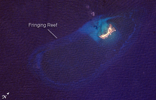 |
| Aves Island Named Isla de Aves in Spanish, (meaning "Island of the Birds") Aves Island lies west of the Lesser Antilles in the Caribbean. It provides a nesting site to green sea turtles (Chelonia mydas) and, of course, birds. Because the abundant bird droppings, known as guano, could be used in fertilizer and gunpowder, guano miners worked on the island until they depleted the supply. Since its discovery by Europeans, likely in the late 16th century, Aves Island was subsequently claimed by several European nations. The island is currently claimed by Venezuela, although disputes about ownership of the island, and the surrounding exclusive economic zone in the Caribbean, continue today. Aves Island is small--only 0.5 by 0.2 kilometers (0.3 by 0.1 miles)--and its highest point stands just 4 meters (13 feet) above sea level. In hurricanes, the island can be completely submerged. In 1980, Hurricane Allen split the island in two, but subsequent coral reef growth reunited the two halves. This astronaut photograph is a rare, almost cloud-free, view of the island and the submerged fringing coral reef that surrounds it. The fringing reef is barely visible, appearing as a ring slightly lighter in color than the ocean water. The crosshatch-like pattern of roughness on the surrounding sea surface is most likely caused by variable winds at the time of image acquisition. |
| Images: | All Available Images Low-Resolution 266k |
|
| Mission: | ISS013 |
|
| Roll - Frame: | E - 27590 |
|
| Geographical Name: | CARIBBEAN SEA |
|
| Features: | AVES ISLAND, CORAL REEFS |
|
| Center Lat x Lon: | 15.7N x 63.6W |
|
| Film Exposure: | N=Normal exposure, U=Under exposed, O=Over exposed, F=out of Focus |
|
| Percentage of Cloud Cover-CLDP: | 10 |
|
| Camera:: | E4 |
|
| Camera Tilt: | 7 | LO=Low Oblique, HO=High Oblique, NV=Near Vertical |
| Camera Focal Length: | 800 |
|
| Nadir to Photo Center Direction: | SE | The direction from the nadir to the center point, N=North, S=South, E=East, W=West |
| Stereo?: | Y=Yes there is an adjacent picture of the same area, N=No there isn't |
|
| Orbit Number: | 2994 |
|
| Date: | 20060527 | YYYYMMDD |
| Time: | 183252 | GMT HHMMSS |
| Nadir Lat: | 16.0N |
Latitude of suborbital point of spacecraft |
| Nadir Lon: | 63.8W |
Longitude of suborbital point of spacecraft |
| Sun Azimuth: | 285 | Clockwise angle in degrees from north to the sun measured at the nadir point |
| Space Craft Altitude: | 185 | nautical miles |
| Sun Elevation: | 56 | Angle in degrees between the horizon and the sun, measured at the nadir point |
| Land Views: | ISLAND |
|
| Water Views: | OCEAN, REEF, SEA |
|
| Atmosphere Views: | HURRICANE |
|
| Man Made Views: | |
|
| City Views: | |
|
Photo is not associated with any sequences | ||
| NASA Home Page |
JSC Home Page |
JSC Digital Image Collection |
Earth Science & Remote Sensing |
|
This service is provided by the International Space Station program and the JSC Earth Science & Remote Sensing Unit, ARES Division, Exploration Integration Science Directorate.

|