Geographic Region: USA-ALASKA
Feature: CLEVELAND VOLCANO,ERUPTION
|
Geographic Region: USA-ALASKA Feature: CLEVELAND VOLCANO,ERUPTION |
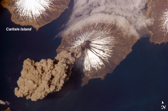 |
| ISS013-E-24184 (23 May 2006) --- Eruption of Cleveland Volcano, Aleutian Islands, Alaska is featured in this image photographed by an Expedition 13 crewmember on the International Space Station. This most recent eruption was first reported to the Alaska Volcano Observatory by astronaut Jeffrey N. Williams, NASA space station science officer and flight engineer, at 3:00 p.m. Alaska Daylight Time (23:00 GMT). This image, acquired shortly after the beginning of the eruption, captures the ash plume moving west-southwest from the summit vent. The eruption was short-lived; the plume had completely detached from the volcano summit two hours later. Ash plumes from Cleveland Volcano have reached heights of 12 kilometers and can present a hazard to trans-Pacific jet flights. The fog bank visible at image top center is a common feature of the Aleutian volcanoes. Cleveland Volcano, situated on the western half of Chuginadak Island, is one of the most active of the volcanoes in the Aleutian Island chain extending west-southwest from the Alaska mainland. At a summit elevation of 1,730 meters, this stratovolcano is the highest in the Islands of the Four Mountains group. Carlisle Island to the north-northwest, another stratovolcano, is also part of this group. Magma that feeds eruptions of ash and lava flows from the volcano is generated by subduction of the northwestward-moving Pacific Plate beneath the North American Plate. As one tectonic plate subducts beneath another, melting of materials above and within the subducting plate produce magma that can eventually move to the surface and erupt through a vent (such as a volcano). Cleveland Volcano claimed the only known eruption-related fatality in the Aleutian Islands during 1944. |
| Images: | All Available Images Low-Resolution 202k |
|
| Mission: | ISS013 |
|
| Roll - Frame: | E - 24184 |
|
| Geographical Name: | USA-ALASKA |
|
| Features: | CLEVELAND VOLCANO,ERUPTION |
|
| Center Lat x Lon: | 52.8N x 170W |
|
| Film Exposure: | N=Normal exposure, U=Under exposed, O=Over exposed, F=out of Focus |
|
| Percentage of Cloud Cover-CLDP: | 10 |
|
| Camera:: | E4 |
|
| Camera Tilt: | 43 | LO=Low Oblique, HO=High Oblique, NV=Near Vertical |
| Camera Focal Length: | 800 |
|
| Nadir to Photo Center Direction: | NW | The direction from the nadir to the center point, N=North, S=South, E=East, W=West |
| Stereo?: | Y=Yes there is an adjacent picture of the same area, N=No there isn't |
|
| Orbit Number: | 2934 |
|
| Date: | 20060523 | YYYYMMDD |
| Time: | 225748 | GMT HHMMSS |
| Nadir Lat: | 50.7N |
Latitude of suborbital point of spacecraft |
| Nadir Lon: | 168W |
Longitude of suborbital point of spacecraft |
| Sun Azimuth: | 175 | Clockwise angle in degrees from north to the sun measured at the nadir point |
| Space Craft Altitude: | 184 | nautical miles |
| Sun Elevation: | 60 | Angle in degrees between the horizon and the sun, measured at the nadir point |
| Land Views: | ISLAND, VOLCANO |
|
| Water Views: | |
|
| Atmosphere Views: | FOG, PLUME |
|
| Man Made Views: | |
|
| City Views: | |
|
Photo is not associated with any sequences | ||
| NASA Home Page |
JSC Home Page |
JSC Digital Image Collection |
Earth Science & Remote Sensing |
|
This service is provided by the International Space Station program and the JSC Earth Science & Remote Sensing Unit, ARES Division, Exploration Integration Science Directorate.

|