
Geographic Region: USA-MICHIGAN
Feature: ROGERS CITY,LIMESTONE QUARRY
|
Geographic Region: USA-MICHIGAN Feature: ROGERS CITY,LIMESTONE QUARRY |
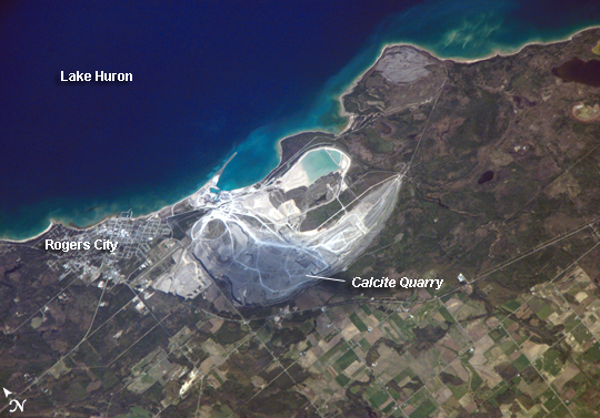 |
| Calcite Quarry, Michigan While the Great Lakes region of North America is well known for its importance to shipping between the United States, Canada, and the Atlantic Ocean, it is also the location of an impressive structure in the continent's bedrock: the Michigan Basin. Formed during the Paleozoic Era (approximately 540-250 million years ago) the Basin looks much like a large bullseye defined by the arrangement of exposed rock layers that all tilt inwards, forming a huge bowl-shaped structure. While this "bowl" is not readily apparent from the ground, detailed mapping of the rock units on a regional scale revealed the structure to geologists. The outer layers of the Basin include thick deposits of carbonates--rocks containing carbon and oxygen, such as limestone--deposited over millions of years when a shallow sea covered the region. These carbonate rocks are mined throughout the Great Lakes region using large open-pit mines. The largest carbonate mine in the world, Calcite Quarry, appears in this astronaut photograph. The mine has been active for over 85 years. The worked area (grey region in image center) measures approximately 7 kilometers long by 4 kilometers wide, and it is crossed by several access roads (white). The rocks are processed to create crushed aggregate, building stone, soil enhancers, lime, additives to steel, and a host of other products. Calcite Quarry ships between 7 and 10.5 million tons of material each year, thanks to the quarry's location on the shores of Lake Huron. Nearby Rogers City was once a typical mining company town, but over time it has expanded its economic base as a summer retreat for sailing and tourism. |
| Images: | All Available Images Low-Resolution 277k |
|
| Mission: | ISS013 |
|
| Roll - Frame: | E - 14843 |
|
| Geographical Name: | USA-MICHIGAN |
|
| Features: | ROGERS CITY,LIMESTONE QUARRY |
|
| Center Lat x Lon: | 45.4N x 83.8W |
|
| Film Exposure: | N=Normal exposure, U=Under exposed, O=Over exposed, F=out of Focus |
|
| Percentage of Cloud Cover-CLDP: | 10 |
|
| Camera:: | E4 |
|
| Camera Tilt: | 37 | LO=Low Oblique, HO=High Oblique, NV=Near Vertical |
| Camera Focal Length: | 800 |
|
| Nadir to Photo Center Direction: | S | The direction from the nadir to the center point, N=North, S=South, E=East, W=West |
| Stereo?: | Y=Yes there is an adjacent picture of the same area, N=No there isn't |
|
| Orbit Number: | 2665 |
|
| Date: | 20060506 | YYYYMMDD |
| Time: | 211724 | GMT HHMMSS |
| Nadir Lat: | 47.6N |
Latitude of suborbital point of spacecraft |
| Nadir Lon: | 84.4W |
Longitude of suborbital point of spacecraft |
| Sun Azimuth: | 256 | Clockwise angle in degrees from north to the sun measured at the nadir point |
| Space Craft Altitude: | 183 | nautical miles |
| Sun Elevation: | 35 | Angle in degrees between the horizon and the sun, measured at the nadir point |
| Land Views: | |
|
| Water Views: | LAKE |
|
| Atmosphere Views: | |
|
| Man Made Views: | MINING |
|
| City Views: | |
|
Photo is not associated with any sequences | ||
| NASA Home Page |
JSC Home Page |
JSC Digital Image Collection |
Earth Science & Remote Sensing |
|
This service is provided by the International Space Station program and the JSC Earth Science & Remote Sensing Unit, ARES Division, Exploration Integration Science Directorate.

|