
Geographic Region: MEXICO
Feature: C. SAN LUCAS, BAY, MTS.,DRAIN.
|
Geographic Region: MEXICO Feature: C. SAN LUCAS, BAY, MTS.,DRAIN. |
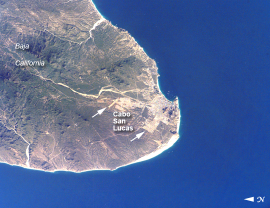 |
| Cabo San Lucas, Baja California Sur, Mexico The built-up areas of Cabo (cape) San Lucas stand out as bright, angular areas inland from the main bay on the tip of the Baja California peninsula. The town is nearly centered on the bay, which looks out onto the blue waters of the Gulf of California. Three dry river beds (white sands in this arid environment) descend from rugged, wooded hills to the coastline. River sands then accumulate to form the white beaches visible along the coastline adjacent to the city. Cabo San Lucas, once just a collection of fishing villages, is now a tourist hotspot (current population 41,000), known for its mild, sunny winter weather. It has grown rapidly in the past few decades, with new neighborhoods sprawling north and northwest (indicated with lines) along major roads. Larger developments stretch northeast along the coast for 40 kilometers from Cabo San Lucas to the slightly larger city of San Jose del Cabo (not visible). Whale watching competes with marlin fishing as one of the area's most popular activities. |
| Images: | All Available Images Low-Resolution 330k |
|
| Mission: | ISS012 |
|
| Roll - Frame: | E - 7151 |
|
| Geographical Name: | MEXICO |
|
| Features: | C. SAN LUCAS, BAY, MTS.,DRAIN. |
|
| Center Lat x Lon: | 22.9N x 109.9W |
|
| Film Exposure: | N=Normal exposure, U=Under exposed, O=Over exposed, F=out of Focus |
|
| Percentage of Cloud Cover-CLDP: | 10 |
|
| Camera:: | E4 |
|
| Camera Tilt: | 50 | LO=Low Oblique, HO=High Oblique, NV=Near Vertical |
| Camera Focal Length: | 400 |
|
| Nadir to Photo Center Direction: | NW | The direction from the nadir to the center point, N=North, S=South, E=East, W=West |
| Stereo?: | Y=Yes there is an adjacent picture of the same area, N=No there isn't |
|
| Orbit Number: | 3799 |
|
| Date: | 20051105 | YYYYMMDD |
| Time: | 221418 | GMT HHMMSS |
| Nadir Lat: | 20.0N |
Latitude of suborbital point of spacecraft |
| Nadir Lon: | 107.7W |
Longitude of suborbital point of spacecraft |
| Sun Azimuth: | 238 | Clockwise angle in degrees from north to the sun measured at the nadir point |
| Space Craft Altitude: | 185 | nautical miles |
| Sun Elevation: | 29 | Angle in degrees between the horizon and the sun, measured at the nadir point |
| Land Views: | CAPE, COAST, PENINSULA |
|
| Water Views: | BAY, GULF, RIVER |
|
| Atmosphere Views: | |
|
| Man Made Views: | |
|
| City Views: | SAN LUCAS, WHITE SANDS |
|
Photo is not associated with any sequences | ||
| NASA Home Page |
JSC Home Page |
JSC Digital Image Collection |
Earth Science & Remote Sensing |
|
This service is provided by the International Space Station program and the JSC Earth Science & Remote Sensing Unit, ARES Division, Exploration Integration Science Directorate.

|