Geographic Region: CHINA
Feature: SMOG HAZE, DUST HAZE,BOHAI B.
|
Geographic Region: CHINA Feature: SMOG HAZE, DUST HAZE,BOHAI B. |
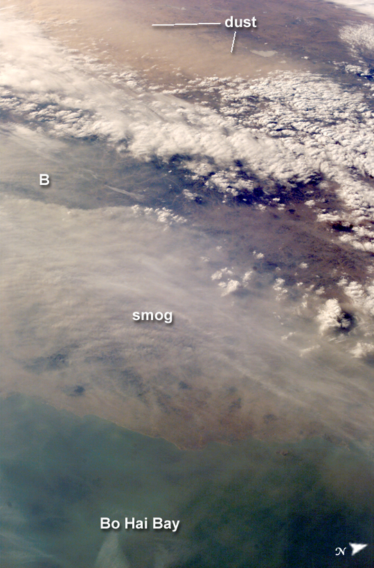 |
| Dust and Smog in Northeast China Much of the land surface is obscured in this oblique image of the North China Plain and parts of Inner Mongolia. In this image, a mass of gray smog--mainly industrial pollution and smoke from domestic burning--obscures Beijing and surrounding cities. Numerous plumes with their source points appear within the mass. Beijing suffers some of the worst air pollution in the world from these chronic sources, and the characteristic colors and textures of the smog can be easily seen through the windows of the International Space Station. The pale brown material in Bo Hai Bay, about 300 kilometers east of Beijing, is sediment from the Yellow River and other rivers. Separated from the smog mass by a band of puffy, white cumulus clouds is a light brown plume of dust. The line of white clouds has developed along the steep slope that separates the heavily populated North China Plain--the location of the largest population concentration on Earth--and the sparsely populated semi-desert plains of Inner Mongolia. Most Northern Hemisphere deserts saw dust storms in the spring of 2006, and the Gobi and Taklimakan Deserts of western China were no exception. Dust plumes originating in these deserts typically extend hundreds of kilometers eastward, regularly depositing dust on Beijing, the Korean Peninsula, and Japan. Some plumes even extend over the Pacific Ocean. In extreme cases, visible masses of Gobi-derived dust have reached North America. An astronaut handheld-camera image taken in 1996 shows a broad corridor of smog moving off the mainland out into the Pacific Ocean from China's more southerly population center near Taiwan. |
| Images: | All Available Images Low-Resolution 426k |
|
| Mission: | ISS012 |
|
| Roll - Frame: | E - 21250 |
|
| Geographical Name: | CHINA |
|
| Features: | SMOG HAZE, DUST HAZE,BOHAI B. |
|
| Center Lat x Lon: | 41.0N x 119.0E |
|
| Film Exposure: | N=Normal exposure, U=Under exposed, O=Over exposed, F=out of Focus |
|
| Percentage of Cloud Cover-CLDP: | 25 |
|
| Camera:: | E4 |
|
| Camera Tilt: | HO | LO=Low Oblique, HO=High Oblique, NV=Near Vertical |
| Camera Focal Length: | 50 |
|
| Nadir to Photo Center Direction: | NW | The direction from the nadir to the center point, N=North, S=South, E=East, W=West |
| Stereo?: | Y=Yes there is an adjacent picture of the same area, N=No there isn't |
|
| Orbit Number: | 1931 |
|
| Date: | 20060321 | YYYYMMDD |
| Time: | 075704 | GMT HHMMSS |
| Nadir Lat: | 38.3N |
Latitude of suborbital point of spacecraft |
| Nadir Lon: | 123.2E |
Longitude of suborbital point of spacecraft |
| Sun Azimuth: | 251 | Clockwise angle in degrees from north to the sun measured at the nadir point |
| Space Craft Altitude: | 185 | nautical miles |
| Sun Elevation: | 23 | Angle in degrees between the horizon and the sun, measured at the nadir point |
| Land Views: | DESERT, PENINSULA, PLAIN |
|
| Water Views: | BAY, OCEAN, RIVER, SEDIMENT |
|
| Atmosphere Views: | DUST, PLUME, SMOG, SMOKE |
|
| Man Made Views: | POLLUTION |
|
| City Views: | BEIJING |
|
Photo is not associated with any sequences | ||
| NASA Home Page |
JSC Home Page |
JSC Digital Image Collection |
Earth Science & Remote Sensing |
|
This service is provided by the International Space Station program and the JSC Earth Science & Remote Sensing Unit, ARES Division, Exploration Integration Science Directorate.

|