
Geographic Region: IRAN
Feature: LINEAR MTS.,DASH-E-LUT SALARS
|
Geographic Region: IRAN Feature: LINEAR MTS.,DASH-E-LUT SALARS |
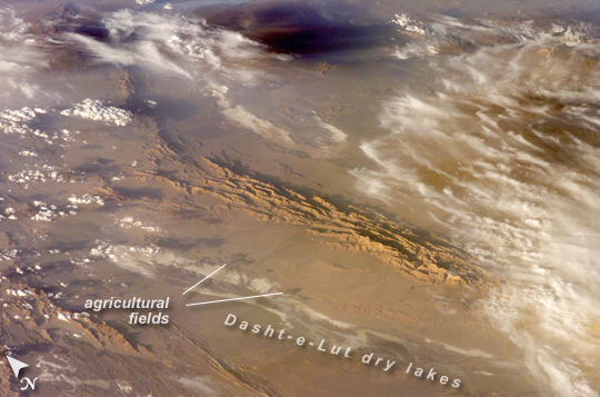 |
| Winter in the Dasht-e-Lut Desert, Eastern Iran An International Space Station crew member took this striking photograph one evening in late February. The image takes advantage of the Sun's low angle to reveal linear geological structures of the Iranian mountain range bordering the western edge of the basin known as Dasht-e-Lut. The range rises 1,818 meters (6,000 feet) above sea level and lies 750 kilometers (466 miles) north of the Persian Gulf. The convoluted appearance results from erosion of folded and faulted rocks--softer rocks erode away quickly, leaving more resistant rock to form linear ridges that are perpendicular to the direction of compression. While not a major oil-producing region like the Zagros Fold Belt to the southwest, the mountains of east-central Iran contain economically important deposits of copper and other metals. Little vegetation can be seen from space in the arid interior basin of the Dasht-e-Lut. Iran is climatically part of the Afro-Asian belt of deserts that stretch from the Cape Verde islands off West Africa all the way to Mongolia near Beijing, China. The patchy, elongated, light-colored feature in the foreground (parallel to the mountain range) is the northernmost of the Dasht dry lakes that stretch southward 300 kilometers (186 miles). In near-tropical deserts, elevated areas capture most precipitation. Agricultural fields that depend on this precipitation appear as small dark patches in this image. They are located downslope, near the margin of the lake's dry, salty soils. |
| Images: | All Available Images Low-Resolution 262k |
|
| Mission: | ISS012 |
|
| Roll - Frame: | E - 18779 |
|
| Geographical Name: | IRAN |
|
| Features: | LINEAR MTS.,DASH-E-LUT SALARS |
|
| Center Lat x Lon: | 33.5N x 57.0E |
|
| Film Exposure: | N=Normal exposure, U=Under exposed, O=Over exposed, F=out of Focus |
|
| Percentage of Cloud Cover-CLDP: | 50 |
|
| Camera:: | E4 |
|
| Camera Tilt: | HO | LO=Low Oblique, HO=High Oblique, NV=Near Vertical |
| Camera Focal Length: | 180 |
|
| Nadir to Photo Center Direction: | NE | The direction from the nadir to the center point, N=North, S=South, E=East, W=West |
| Stereo?: | Y=Yes there is an adjacent picture of the same area, N=No there isn't |
|
| Orbit Number: | 1604 |
|
| Date: | 20060228 | YYYYMMDD |
| Time: | 132150 | GMT HHMMSS |
| Nadir Lat: | 27.5N |
Latitude of suborbital point of spacecraft |
| Nadir Lon: | 51.8E |
Longitude of suborbital point of spacecraft |
| Sun Azimuth: | 253 | Clockwise angle in degrees from north to the sun measured at the nadir point |
| Space Craft Altitude: | 186 | nautical miles |
| Sun Elevation: | 15 | Angle in degrees between the horizon and the sun, measured at the nadir point |
| Land Views: | BASIN, CAPE, DESERT, EROSION, MOUNTAIN, RANGE |
|
| Water Views: | GULF, LAKE, SEA |
|
| Atmosphere Views: | |
|
| Man Made Views: | |
|
| City Views: | BEIJING |
|
Photo is not associated with any sequences | ||
| NASA Home Page |
JSC Home Page |
JSC Digital Image Collection |
Earth Science & Remote Sensing |
|
This service is provided by the International Space Station program and the JSC Earth Science & Remote Sensing Unit, ARES Division, Exploration Integration Science Directorate.

|