
Geographic Region: IRAN
Feature: ZAGROS MTS., SALT DOME
|
Geographic Region: IRAN Feature: ZAGROS MTS., SALT DOME |
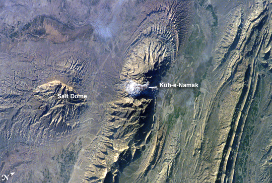 |
| Salt Dome in the Zagros Mountains, Iran The Zagros Mountains in southwestern Iran present an impressive landscape of long linear ridges and valleys. Formed by collision of the Eurasian and Arabian tectonic plates, the ridges and valleys extend hundreds of kilometers. Stresses induced in the Earth's crust by the collision caused extensive folding of the preexisting layered sedimentary rocks. Subsequent erosion removed softer rocks, such as mudstone (rock formed by consolidated mud) and siltstone (a slightly coarser-grained mudstone) while leaving harder rocks, such as limestone (calcium-rich rock consisting of the remains of marine organisms) and dolomite (rocks similar to limestone containing calcium and magnesium). This differential erosion formed the linear ridges of the Zagros Mountains. The depositional environment and tectonic history of the rocks were conducive to the formation and trapping of petroleum, and the Zagros region is an important part of Persian Gulf production. This astronaut photograph of the southwestern edge of the Zagros mountain belt includes another common feature of the region--a salt dome (Kuh-e-Namak or "mountain of salt" in Farsi). Thick layers of minerals such as halite (common table salt) typically accumulate in closed basins during alternating wet and dry climatic conditions. Over geologic time, these layers of salt are buried under younger layers of rock. The pressure from overlying rock layers causes the lower-density salt to flow upwards, bending the overlying rock layers and creating a dome-like structure. Erosion has spectacularly revealed the uplifted tan and brown rock layers surrounding the white Kuh-e-Namak to the northwest and southeast (center of image). Radial drainage patterns indicate another salt dome is located to the southwest (image left center). If the rising plug of salt (called a salt diapir) breaches the surface, it can become a flowing salt glacier. Salt domes are an important target for oil exploration, as the impermeable salt frequently traps petroleum beneath other rock layers. |
| Images: | All Available Images Low-Resolution 357k |
|
| Mission: | ISS012 |
|
| Roll - Frame: | E - 18774 |
|
| Geographical Name: | IRAN |
|
| Features: | ZAGROS MTS., SALT DOME |
|
| Center Lat x Lon: | 28.0N x 51.5E |
|
| Film Exposure: | N=Normal exposure, U=Under exposed, O=Over exposed, F=out of Focus |
|
| Percentage of Cloud Cover-CLDP: | 10 |
|
| Camera:: | E4 |
|
| Camera Tilt: | 52 | LO=Low Oblique, HO=High Oblique, NV=Near Vertical |
| Camera Focal Length: | 180 |
|
| Nadir to Photo Center Direction: | NE | The direction from the nadir to the center point, N=North, S=South, E=East, W=West |
| Stereo?: | Y=Yes there is an adjacent picture of the same area, N=No there isn't |
|
| Orbit Number: | 1604 |
|
| Date: | 20060228 | YYYYMMDD |
| Time: | 132053 | GMT HHMMSS |
| Nadir Lat: | 24.8N |
Latitude of suborbital point of spacecraft |
| Nadir Lon: | 49.1E |
Longitude of suborbital point of spacecraft |
| Sun Azimuth: | 252 | Clockwise angle in degrees from north to the sun measured at the nadir point |
| Space Craft Altitude: | 186 | nautical miles |
| Sun Elevation: | 18 | Angle in degrees between the horizon and the sun, measured at the nadir point |
| Land Views: | EROSION, GLACIER, MOUNTAIN |
|
| Water Views: | GULF |
|
| Atmosphere Views: | |
|
| Man Made Views: | |
|
| City Views: | |
|
Photo is not associated with any sequences | ||
| NASA Home Page |
JSC Home Page |
JSC Digital Image Collection |
Earth Science & Remote Sensing |
|
This service is provided by the International Space Station program and the JSC Earth Science & Remote Sensing Unit, ARES Division, Exploration Integration Science Directorate.

|