
Geographic Region: USA-OHIO
Feature: SANDUSKY, BAY, SED. PLUMES
|
Geographic Region: USA-OHIO Feature: SANDUSKY, BAY, SED. PLUMES |
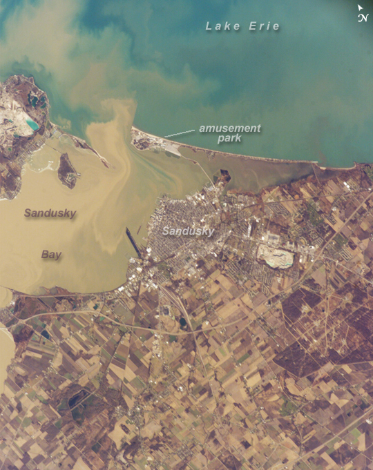 |
| Sandusky, Ohio Muddy brown water fills Sandusky Bay, just south of Lake Erie in this astronaut photograph. The small city of Sandusky occupies the southeastern shore of the bay. Highway 2 can be seen arcing around the south side of the city. Ferries connect Sandusky to Pelee Island (not visible) in the middle of the lake. In earlier days, Sandusky Bay was known as one of the port sites best protected from rough waters in the Great Lakes. The most striking aspect of this image is the flow of the brown water in and out of the mouth of the bay. Slight movement of lake surface water, driven mainly by wind, causes a small ebb and flow of bay water. Sediment-charged water is derived from agricultural fields along the Sandusky River upstream. Mud plumes in Lake Erie originate from prior pulses of muddy water from the bay. When this image was taken, some clear, lake water (blue-green strip) appeared to be flowing into the bay. Sandusky lies midway between Toledo and Cleveland, both about an hour's drive away. Sandusky has a diverse economic base in engineering and chemical plants, as well as boasting one of the most popular vacation destinations in the United States, drawing millions of visitors each year to its very large amusement park, located on the eastern spit between Sandusky Bay and Lake Erie. NASA Glenn Research Center - Plum Brook Station also appears in this image, in the lower right corner. |
| Images: | All Available Images Low-Resolution 387k |
|
| Mission: | ISS012 |
|
| Roll - Frame: | E - 15050 |
|
| Geographical Name: | USA-OHIO |
|
| Features: | SANDUSKY, BAY, SED. PLUMES |
|
| Center Lat x Lon: | 41.4N x 82.7W |
|
| Film Exposure: | N=Normal exposure, U=Under exposed, O=Over exposed, F=out of Focus |
|
| Percentage of Cloud Cover-CLDP: | 10 |
|
| Camera:: | E4 |
|
| Camera Tilt: | 31 | LO=Low Oblique, HO=High Oblique, NV=Near Vertical |
| Camera Focal Length: | 400 |
|
| Nadir to Photo Center Direction: | W | The direction from the nadir to the center point, N=North, S=South, E=East, W=West |
| Stereo?: | Y=Yes there is an adjacent picture of the same area, N=No there isn't |
|
| Orbit Number: | 867 |
|
| Date: | 20060112 | YYYYMMDD |
| Time: | 183959 | GMT HHMMSS |
| Nadir Lat: | 41.8N |
Latitude of suborbital point of spacecraft |
| Nadir Lon: | 80.9W |
Longitude of suborbital point of spacecraft |
| Sun Azimuth: | 197 | Clockwise angle in degrees from north to the sun measured at the nadir point |
| Space Craft Altitude: | 184 | nautical miles |
| Sun Elevation: | 25 | Angle in degrees between the horizon and the sun, measured at the nadir point |
| Land Views: | ISLAND |
|
| Water Views: | BAY, LAKE, RIVER, SEDIMENT |
|
| Atmosphere Views: | |
|
| Man Made Views: | HIGHWAY, PORT |
|
| City Views: | CLEVELAND, ERIE, SANDUSKY, TOLEDO |
|
Photo is not associated with any sequences | ||
| NASA Home Page |
JSC Home Page |
JSC Digital Image Collection |
Earth Science & Remote Sensing |
|
This service is provided by the International Space Station program and the JSC Earth Science & Remote Sensing Unit, ARES Division, Exploration Integration Science Directorate.

|