
Geographic Region: CHINA
Feature: PUMA LAKE,ICE,TIBETAN PLATEAU
|
Geographic Region: CHINA Feature: PUMA LAKE,ICE,TIBETAN PLATEAU |
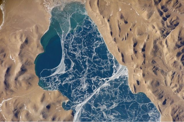 |
| Lake Puma Yumco, Tibet, China The alpine lakes of the Tibetan Plateau are some of the most remote in the world. This mosaic of astronaut photographs, taken along a single International Space Station orbit track, depicts Lake Puma Yumco during the winter season. The lake is located at an elevation of 5,030 meters above sea level (16,503 feet), and is considered ultraoligotrophic, meaning that nutrient concentrations in both the water column and lake sediments are extremely low. Water in such lakes tends to be blue to blue-green and to have high clarity due to low levels of photosynthesizing organisms such as phytoplankton. Color change in these lakes is usually due to shallowing of the water--blue indicating deeper water. A depth transition is visible along the west-southwest shoreline of Lake Puma Yumco at the lower left of image. The most striking feature of the image mosaic is the intricate ice block pattern on the lake surface. The maximum dimensions of the lake are 31 kilometers by 14 kilometers (1 kilometer is about 0.6 miles), indicating that the ice blocks range from less than ten to hundreds of meters in diameter. The ice pattern is caused by repeated cycles of freezing, fracturing, and refreezing of the ice due to variations in temperature and wind-induced ice motion. A prominent white linear feature extending north-south across the center of the lake is suggestive of an ice ridge formed by east-west winds subsequently highlighted by snow. Similar features are visible along the eastern and southern shorelines and in the southwestern portion of the lake. Records from the nearest weather station to Lake Puma Yumco (approximately 140 kilometers to the northeast at Llasa, Tibet) indicate that daily day-night temperatures varied on average from -7 to 14 degrees Celsius (about 19 to 57 degrees Fahrenheit) during the week preceding acquisition of the astronaut photographs. |
| Images: | All Available Images Low-Resolution 57k |
|
| Mission: | ISS012 |
|
| Roll - Frame: | E - 14618 |
|
| Geographical Name: | CHINA |
|
| Features: | PUMA LAKE,ICE,TIBETAN PLATEAU |
|
| Center Lat x Lon: | 28.6N x 90.3E |
|
| Film Exposure: | N=Normal exposure, U=Under exposed, O=Over exposed, F=out of Focus |
|
| Percentage of Cloud Cover-CLDP: | 0 |
|
| Camera:: | E4 |
|
| Camera Tilt: | 21 | LO=Low Oblique, HO=High Oblique, NV=Near Vertical |
| Camera Focal Length: | 400 |
|
| Nadir to Photo Center Direction: | E | The direction from the nadir to the center point, N=North, S=South, E=East, W=West |
| Stereo?: | Y=Yes there is an adjacent picture of the same area, N=No there isn't |
|
| Orbit Number: | 766 |
|
| Date: | 20060106 | YYYYMMDD |
| Time: | 084014 | GMT HHMMSS |
| Nadir Lat: | 28.6N |
Latitude of suborbital point of spacecraft |
| Nadir Lon: | 89.1E |
Longitude of suborbital point of spacecraft |
| Sun Azimuth: | 220 | Clockwise angle in degrees from north to the sun measured at the nadir point |
| Space Craft Altitude: | 186 | nautical miles |
| Sun Elevation: | 27 | Angle in degrees between the horizon and the sun, measured at the nadir point |
| Land Views: | PLATEAU, RANGE |
|
| Water Views: | ICE, LAKE, SEA |
|
| Atmosphere Views: | |
|
| Man Made Views: | |
|
| City Views: | |
|
Photo is not associated with any sequences | ||
| NASA Home Page |
JSC Home Page |
JSC Digital Image Collection |
Earth Science & Remote Sensing |
|
This service is provided by the International Space Station program and the JSC Earth Science & Remote Sensing Unit, ARES Division, Exploration Integration Science Directorate.

|