
Geographic Region: USA-LOUISIANA
Feature: BASTROP,SMOKE PLUME,GLINT
|
Geographic Region: USA-LOUISIANA Feature: BASTROP,SMOKE PLUME,GLINT |
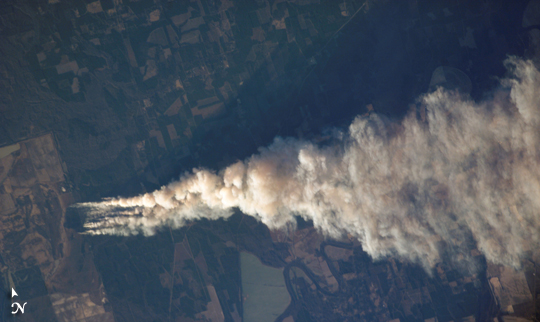 |
| Forest Fire, Ouachita National Wildlife Refuge, LA Dry conditions and high winds have lead to numerous recent fire outbreaks throughout much of the southwestern and south-central USA. Drought conditions have persisted in the region for months, leading to a build-up of fire fuels, including dried grasses, shrubs, and trees. The combination of high amounts of dry fuel and frequent high winds has stoked small fires into widespread brush fires. This astronaut photograph captures a 25-kilometer long smoke plume from a fire in the Upper Ouachita National Wildlife Refuge in northeastern Louisiana. The fire started at approximately 1:00 p.m. on January 2, 2006, and this image was acquired approximately three and a half hours later as the International Space Station passed over the Texas-Louisiana border, to the southwest of the scene. The long extent of the plume reflects the strong westerly winds that drove the fire eastwards and damaged an estimated 200-300 acres of the wildlife refuge. The striking illumination of the plume is caused by a very low sun angle (the angle between the horizon and the Sun at the point on the ground directly below the Space Station). Although the plume is well illuminated, the low sun angle results in low illumination of other scene features, such as agricultural fields adjacent to the refuge. |
| Images: | All Available Images Low-Resolution 164k |
|
| Mission: | ISS012 |
|
| Roll - Frame: | E - 13692 |
|
| Geographical Name: | USA-LOUISIANA |
|
| Features: | BASTROP,SMOKE PLUME,GLINT |
|
| Center Lat x Lon: | 32.9N x 92W |
|
| Film Exposure: | N=Normal exposure, U=Under exposed, O=Over exposed, F=out of Focus |
|
| Percentage of Cloud Cover-CLDP: | 10 |
|
| Camera:: | E4 |
|
| Camera Tilt: | 39 | LO=Low Oblique, HO=High Oblique, NV=Near Vertical |
| Camera Focal Length: | 400 |
|
| Nadir to Photo Center Direction: | NE | The direction from the nadir to the center point, N=North, S=South, E=East, W=West |
| Stereo?: | Y=Yes there is an adjacent picture of the same area, N=No there isn't |
|
| Orbit Number: | 712 |
|
| Date: | 20060102 | YYYYMMDD |
| Time: | 222403 | GMT HHMMSS |
| Nadir Lat: | 30.8N |
Latitude of suborbital point of spacecraft |
| Nadir Lon: | 93.4W |
Longitude of suborbital point of spacecraft |
| Sun Azimuth: | 235 | Clockwise angle in degrees from north to the sun measured at the nadir point |
| Space Craft Altitude: | 185 | nautical miles |
| Sun Elevation: | 10 | Angle in degrees between the horizon and the sun, measured at the nadir point |
| Land Views: | FOREST |
|
| Water Views: | |
|
| Atmosphere Views: | PLUME, SMOKE |
|
| Man Made Views: | |
|
| City Views: | |
|
Photo is not associated with any sequences | ||
| NASA Home Page |
JSC Home Page |
JSC Digital Image Collection |
Earth Science & Remote Sensing |
|
This service is provided by the International Space Station program and the JSC Earth Science & Remote Sensing Unit, ARES Division, Exploration Integration Science Directorate.

|