Geographic Region: RUSSIAN FEDERATION
Feature: IRKUTSK, ANGARA R., AIRPORT
|
Geographic Region: RUSSIAN FEDERATION Feature: IRKUTSK, ANGARA R., AIRPORT |
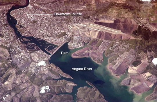 |
| Irkutsk, Siberia, Russian Federation Located about 55 kilometers (34 miles) to the northwest of Lake Baikal, Irkutsk is also the chief city of Irkutsk Oblast (province) in Siberia. The city is located on the Angara River and was originally a tax collection outpost for local fur trappers. Irkutsk formally became a town in 1686. Following a revolt against Tsar Nicholas I in 1825, the city became a center for revolutionaries exiled to Siberia. The relocation of many artists, Imperial army officers, and nobles was an important factor in the establishment of the cultural and architectural character of the city. Following the Bolshevik Revolution of 1917, Irkutsk was the site of many battles during the civil war between the White and Red armies. Today Irkutsk is a major economic, academic, and cultural center in Siberia. This astronaut photograph shows the central downtown area of the city, as well as the Akademgorodok district around the State University (left of image along the southern bank of the Angara River). The oblique (non-vertical) perspective of this photograph imparts a three dimension perspective to the scene, with shadows accentuating the blockiness of Soviet-era building projects to the east of the downtown area. The Irkutsk Dam (image center), built for hydroelectric power, dramatically widened the river and drowned several stream outlet channels along the north and south banks. The Angara River is the only outlet from Lake Baikal to the southeast, and impoundment of water behind the dam has raised the Lake Baikal by 6 meters (20 feet). |
| Images: | All Available Images Low-Resolution 298k |
|
| Mission: | ISS011 |
|
| Roll - Frame: | E - 9913 |
|
| Geographical Name: | RUSSIAN FEDERATION |
|
| Features: | IRKUTSK, ANGARA R., AIRPORT |
|
| Center Lat x Lon: | 52.2N x 104.4E |
|
| Film Exposure: | N=Normal exposure, U=Under exposed, O=Over exposed, F=out of Focus |
|
| Percentage of Cloud Cover-CLDP: | 10 |
|
| Camera:: | N1 |
|
| Camera Tilt: | 43 | LO=Low Oblique, HO=High Oblique, NV=Near Vertical |
| Camera Focal Length: | 800 |
|
| Nadir to Photo Center Direction: | N | The direction from the nadir to the center point, N=North, S=South, E=East, W=West |
| Stereo?: | Y=Yes there is an adjacent picture of the same area, N=No there isn't |
|
| Orbit Number: | 1194 |
|
| Date: | 20050524 | YYYYMMDD |
| Time: | 095907 | GMT HHMMSS |
| Nadir Lat: | 49.3N |
Latitude of suborbital point of spacecraft |
| Nadir Lon: | 104.4E |
Longitude of suborbital point of spacecraft |
| Sun Azimuth: | 273 | Clockwise angle in degrees from north to the sun measured at the nadir point |
| Space Craft Altitude: | 186 | nautical miles |
| Sun Elevation: | 25 | Angle in degrees between the horizon and the sun, measured at the nadir point |
| Land Views: | |
|
| Water Views: | LAKE, RIVER |
|
| Atmosphere Views: | |
|
| Man Made Views: | DAM, UNIVERSITY |
|
| City Views: | |
|
Photo is not associated with any sequences | ||
| NASA Home Page |
JSC Home Page |
JSC Digital Image Collection |
Earth Science & Remote Sensing |
|
This service is provided by the International Space Station program and the JSC Earth Science & Remote Sensing Unit, ARES Division, Exploration Integration Science Directorate.

|