
Geographic Region: USA-UTAH
Feature: LONE PK., DRAPER, FOR., SNOW
|
Geographic Region: USA-UTAH Feature: LONE PK., DRAPER, FOR., SNOW |
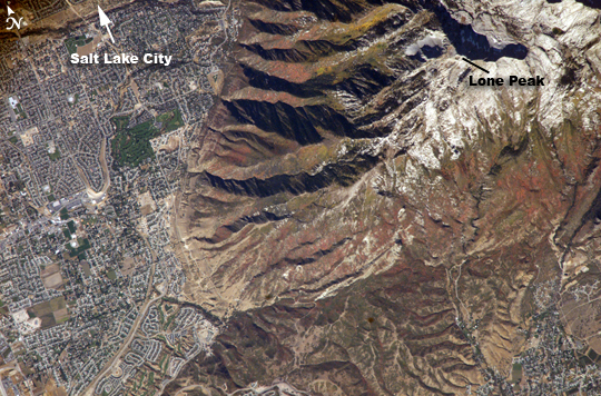 |
| Fall Colors in the Wasatch Range, Utah The Wasatch Range forms an impressive backdrop to the Salt Lake City metropolitan area, and it is a frequent destination for hikers, backpackers, and skiers. The range is considered to be the westernmost part of the Rocky Mountains, and rises to elevations of approximately 3,600 meters (12,000 feet) above sea level. The abundance of streams and building materials (timber and stone) encouraged the earliest Mormon settlers to establish themselves along the western front of the Wasatch Range. Development of the region still occurs mainly along the western mountain front. The cooling days of autumn find the Wasatch Range clothed in the leaves of deciduous trees turning color. This astronaut photograph, taken at the end of September, captures red- (maple trees) and gold-mantled (aspen trees) hill slopes along the western mountain front to the south of Salt Lake City. Other common tree species at these elevations include pine, fir, spruce, willow, birch, and oak. A portion of Draper City is visible in the left half of the image. The elevation of Lone Peak, visible at upper right, is approximately 3,410 meters (11,253 feet). |
| Images: | All Available Images Low-Resolution 352k |
|
| Mission: | ISS011 |
|
| Roll - Frame: | E - 13889 |
|
| Geographical Name: | USA-UTAH |
|
| Features: | LONE PK., DRAPER, FOR., SNOW |
|
| Center Lat x Lon: | 40.5N x 111.8W |
|
| Film Exposure: | N=Normal exposure, U=Under exposed, O=Over exposed, F=out of Focus |
|
| Percentage of Cloud Cover-CLDP: | 10 |
|
| Camera:: | E4 |
|
| Camera Tilt: | 9 | LO=Low Oblique, HO=High Oblique, NV=Near Vertical |
| Camera Focal Length: | 800 |
|
| Nadir to Photo Center Direction: | SW | The direction from the nadir to the center point, N=North, S=South, E=East, W=West |
| Stereo?: | Y=Yes there is an adjacent picture of the same area, N=No there isn't |
|
| Orbit Number: | 3231 |
|
| Date: | 20050930 | YYYYMMDD |
| Time: | 211327 | GMT HHMMSS |
| Nadir Lat: | 40.9N |
Latitude of suborbital point of spacecraft |
| Nadir Lon: | 111.5W |
Longitude of suborbital point of spacecraft |
| Sun Azimuth: | 219 | Clockwise angle in degrees from north to the sun measured at the nadir point |
| Space Craft Altitude: | 185 | nautical miles |
| Sun Elevation: | 39 | Angle in degrees between the horizon and the sun, measured at the nadir point |
| Land Views: | HILL, MOUNTAIN, RANGE |
|
| Water Views: | FRONT, LAKE, SEA |
|
| Atmosphere Views: | |
|
| Man Made Views: | |
|
| City Views: | ASPEN, SALT LAKE CITY |
|
Photo is not associated with any sequences | ||
| NASA Home Page |
JSC Home Page |
JSC Digital Image Collection |
Earth Science & Remote Sensing |
|
This service is provided by the International Space Station program and the JSC Earth Science & Remote Sensing Unit, ARES Division, Exploration Integration Science Directorate.

|