
Geographic Region: USA-MISSISSIPPI
Feature: BILOXI, OCEAN SPRINGS, BACK B.
|
Geographic Region: USA-MISSISSIPPI Feature: BILOXI, OCEAN SPRINGS, BACK B. |
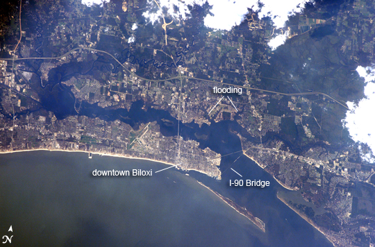 |
| Hurricane Damage in Biloxi, Mississippi The port town of Biloxi, Mississippi experienced significant damage when Hurricane Katrina came ashore on August 29, 2005. Biloxi was established in 1838 following Mississippi statehood in 1817. The town was a favorite vacation destination for other Gulf Coast cities, particularly New Orleans, throughout the 19th and 20th centuries. Keesler Air Force Base was established in Biloxi in 1947; the runways are visible to the west of the downtown area in the top image. The legalization of dockside gambling and casinos in 1992 helped to invigorate the town's economy, but many of the casinos were severely damaged by the hurricane. Katrina isn't the first hurricane to strike Biloxi during its 280-year history. Several hurricanes have battered the town, but the most powerful prior to Katrina was Hurricane Camille in 1969. The astronaut photograph (top) illustrates damage and flooding in the Biloxi area caused by Hurricane Katrina. A Landsat Enhanced Thematic Mapper Plus image (bottom), acquired in 2000, provides a base for comparison. Damage to the 2.5 kilometer (1.6 mile) long US-90 bridge is evident in the astronaut photograph--the bridge is almost completely destroyed with only two sections of roadbed still intact. Flooded areas are indicated by dark greenish-brown coloration along river courses to the northeast and northwest of downtown. Most of the flood water remains within the rivers' floodplains, which are defined by reddish-brown sediment in the Landsat image. |
| Images: | All Available Images Low-Resolution 295k |
|
| Mission: | ISS011 |
|
| Roll - Frame: | E - 12547 |
|
| Geographical Name: | USA-MISSISSIPPI |
|
| Features: | BILOXI, OCEAN SPRINGS, BACK B. |
|
| Center Lat x Lon: | 30.4N x 88.9W |
|
| Film Exposure: | N=Normal exposure, U=Under exposed, O=Over exposed, F=out of Focus |
|
| Percentage of Cloud Cover-CLDP: | 10 |
|
| Camera:: | E4 |
|
| Camera Tilt: | 27 | LO=Low Oblique, HO=High Oblique, NV=Near Vertical |
| Camera Focal Length: | 400 |
|
| Nadir to Photo Center Direction: | SW | The direction from the nadir to the center point, N=North, S=South, E=East, W=West |
| Stereo?: | Y=Yes there is an adjacent picture of the same area, N=No there isn't |
|
| Orbit Number: | 2885 |
|
| Date: | 20050908 | YYYYMMDD |
| Time: | 212204 | GMT HHMMSS |
| Nadir Lat: | 31.3N |
Latitude of suborbital point of spacecraft |
| Nadir Lon: | 87.6W |
Longitude of suborbital point of spacecraft |
| Sun Azimuth: | 254 | Clockwise angle in degrees from north to the sun measured at the nadir point |
| Space Craft Altitude: | 187 | nautical miles |
| Sun Elevation: | 34 | Angle in degrees between the horizon and the sun, measured at the nadir point |
| Land Views: | COAST |
|
| Water Views: | FLOODING, GULF, RIVER, SEDIMENT |
|
| Atmosphere Views: | HURRICANE |
|
| Man Made Views: | BRIDGE, PORT |
|
| City Views: | BILOXI, NEW ORLEANS |
|
Photo is not associated with any sequences | ||
| NASA Home Page |
JSC Home Page |
JSC Digital Image Collection |
Earth Science & Remote Sensing |
|
This service is provided by the International Space Station program and the JSC Earth Science & Remote Sensing Unit, ARES Division, Exploration Integration Science Directorate.

|