Geographic Region: RUSSIAN FEDERATION
Feature: G. FINLAND, L. LADOGA, GLINT
|
Geographic Region: RUSSIAN FEDERATION Feature: G. FINLAND, L. LADOGA, GLINT |
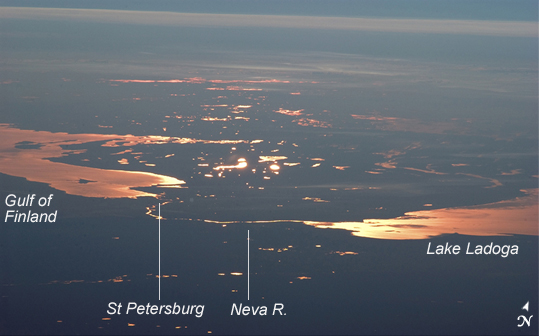 |
| St. Petersburg and the Gulf of Finland This strongly oblique (from the side) view shows the Gulf of Finland and Lake Ladoga in the late afternoon. At this time of day, sunglint--the reflection of sunlight into the camera lens--distinguishes the bodies of water from their surroundings. The image was taken from the International Space Station when the craft orbited north of the Caspian Sea, approximately 2,500 kilometers (1600 miles) to the southeast on the Russia-Kazakhstan border. Lakes in Finland in the middle of the view are 3,000 kilometers (1900 miles) from the camera. The Neva River appears in sunglint, connecting Lake Ladoga to the gulf. Czar Peter the Great constructed St. Petersburg, starting in 1703, on the Neva River Delta. He established this city as his capital and window into Europe via the Baltic Sea. (Although not visible, St. Petersburg--the home town of Sergei Krikalev, Space Station commander when this picture was taken--lies on the Neva River delta.) In this view, taken with a powerful 400-millimeter lens, sunglint even reveals the causeways to Kotlin Island in the gulf--including some of the details of their construction. Oblique views reveal marked layers of gray haze generated by air pollution (top image, top of view), a common sight over Western Europe. Pollution also renders the bright glint areas a coppery color. |
| Images: | All Available Images Low-Resolution 132k |
|
| Mission: | ISS011 |
|
| Roll - Frame: | E - 12401 |
|
| Geographical Name: | RUSSIAN FEDERATION |
|
| Features: | G. FINLAND, L. LADOGA, GLINT |
|
| Center Lat x Lon: | 60.0N x 30.7E |
|
| Film Exposure: | N=Normal exposure, U=Under exposed, O=Over exposed, F=out of Focus |
|
| Percentage of Cloud Cover-CLDP: | 10 |
|
| Camera:: | N1 |
|
| Camera Tilt: | HO | LO=Low Oblique, HO=High Oblique, NV=Near Vertical |
| Camera Focal Length: | 400 |
|
| Nadir to Photo Center Direction: | NW | The direction from the nadir to the center point, N=North, S=South, E=East, W=West |
| Stereo?: | Y=Yes there is an adjacent picture of the same area, N=No there isn't |
|
| Orbit Number: | 1939 |
|
| Date: | 20050710 | YYYYMMDD |
| Time: | 181346 | GMT HHMMSS |
| Nadir Lat: | 50.1N |
Latitude of suborbital point of spacecraft |
| Nadir Lon: | 47.9E |
Longitude of suborbital point of spacecraft |
| Sun Azimuth: | 323 | Clockwise angle in degrees from north to the sun measured at the nadir point |
| Space Craft Altitude: | 187 | nautical miles |
| Sun Elevation: | -10 | Angle in degrees between the horizon and the sun, measured at the nadir point |
| Land Views: | ISLAND |
|
| Water Views: | DELTA, GULF, LAKE, RIVER, SEA, SUNGLINT |
|
| Atmosphere Views: | HAZE |
|
| Man Made Views: | POLLUTION |
|
| City Views: | ST. PETERSBURG |
|
Photo is not associated with any sequences | ||
| NASA Home Page |
JSC Home Page |
JSC Digital Image Collection |
Earth Science & Remote Sensing |
|
This service is provided by the International Space Station program and the JSC Earth Science & Remote Sensing Unit, ARES Division, Exploration Integration Science Directorate.

|