Geographic Region: USA-ALASKA
Feature: MT. MCKINLEY, ALASKA RA.,GL.
|
Geographic Region: USA-ALASKA Feature: MT. MCKINLEY, ALASKA RA.,GL. |
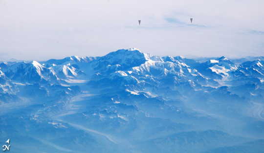 |
| Forest Fire Smoke Surrounding Mt. McKinley This view of Mt McKinley (Denali)--the highest point in North America (6,194 meters; 20,230 feet)--looks as if it were taken from an aircraft. In fact, an astronaut onboard the International Space Station took advantage of cloud-free skies and a powerful 800-millimeter lens to photograph this peak while the spacecraft was over the Gulf of Alaska, 800 miles to the south of the mountain. The powerful lenses are difficult to use, requiring motion compensation by the astronaut, so these kinds of detailed images of horizon detail are seldom taken. The rising sun casts long shadows across the Kahiltna Glacier that angles down from Denali (left). In addition to the blueness inherent in all images taken at great distance (the atmosphere scatters blue light more than it does other colors), this image also shows unusually dense atmospheric haze at lower altitudes: all the valleys in the foreground appear murky. The explanation is dramatically portrayed in a Moderate Resolution Imaging Spectroradiometer (MODIS) image taken on the same day, Sunday, August 14, from the Terra satellite. On that day, an enormous smoke pall hung over central Alaska; all the major mountain ranges protruded above the smoke layer, which was held close to the surface by high atmospheric pressure. The smoke came from more than 100 forest fires burning in the summer heat of Alaska. The MODIS image shows that the smoke on August 14 was far thicker to the north of the Alaska Range where Denali is. The Space Station image shows this denser smoke settled between the Alaska Range and the distant horizon of the Kuskokwim Mountains, 80 miles to the north. |
| Images: | All Available Images Low-Resolution 158k |
|
| Mission: | ISS011 |
|
| Roll - Frame: | E - 11805 |
|
| Geographical Name: | USA-ALASKA |
|
| Features: | MT. MCKINLEY, ALASKA RA.,GL. |
|
| Center Lat x Lon: | 63.1N x 151W |
|
| Film Exposure: | N=Normal exposure, U=Under exposed, O=Over exposed, F=out of Focus |
|
| Percentage of Cloud Cover-CLDP: | 25 |
|
| Camera:: | E4 |
|
| Camera Tilt: | HO | LO=Low Oblique, HO=High Oblique, NV=Near Vertical |
| Camera Focal Length: | 800 |
|
| Nadir to Photo Center Direction: | N | The direction from the nadir to the center point, N=North, S=South, E=East, W=West |
| Stereo?: | Y=Yes there is an adjacent picture of the same area, N=No there isn't |
|
| Orbit Number: | 2488 |
|
| Date: | 20050814 | YYYYMMDD |
| Time: | 155609 | GMT HHMMSS |
| Nadir Lat: | 51.8N |
Latitude of suborbital point of spacecraft |
| Nadir Lon: | 148W |
Longitude of suborbital point of spacecraft |
| Sun Azimuth: | 81 | Clockwise angle in degrees from north to the sun measured at the nadir point |
| Space Craft Altitude: | 188 | nautical miles |
| Sun Elevation: | 11 | Angle in degrees between the horizon and the sun, measured at the nadir point |
| Land Views: | FOREST, GLACIER, MOUNTAIN, RANGE |
|
| Water Views: | GULF |
|
| Atmosphere Views: | HAZE, SMOKE, SMOKE PALL |
|
| Man Made Views: | |
|
| City Views: | |
|
Photo is not associated with any sequences | ||
| NASA Home Page |
JSC Home Page |
JSC Digital Image Collection |
Earth Science & Remote Sensing |
|
This service is provided by the International Space Station program and the JSC Earth Science & Remote Sensing Unit, ARES Division, Exploration Integration Science Directorate.

|