Geographic Region: INDIA
Feature: SAMBHAR, SALTWORKS, AGR.
|
Geographic Region: INDIA Feature: SAMBHAR, SALTWORKS, AGR. |
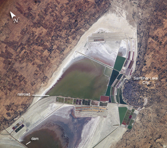 |
| Lake Sambhar, India Lake Sambhar, India's largest salt lake, sits west of the Indian city of Jaipur (Rajasthan, NW India). On the eastern end, the lake is divided by a 5-km long dam made of stone. East of the dam are salt evaporation ponds where salt has been farmed for a thousand years. This image, taken by astronauts aboard the International Space Station, shows Lake Sambhar's eastern saltworks in detail. Today, they are operated by a joint venture between Hindustan Salts and the Government of Rajasthan. East of the dam is a railroad, built by the British (before India's independence) that provides access from Sambhar Lake City to the salt works. More importantly, Sambhar has been designated as a Ramsar site (recognized wetland of international importance) because the wetland is a key wintering area for tens of thousands of flamingos and other birds that migrate from northern Asia. The lake is actually an extensive saline wetland, with water depths fluctuating from just a few centimeters (1 inch) during the dry season to about 3 meters (10 feet) after monsoon season. The specialized algae and bacteria growing in the lake provide striking water colors and support the lake ecology that, in turn, sustains the migrating waterfowl. |
| Images: | All Available Images Low-Resolution 373k |
|
| Mission: | ISS010 |
|
| Roll - Frame: | E - 8524 |
|
| Geographical Name: | INDIA |
|
| Features: | SAMBHAR, SALTWORKS, AGR. |
|
| Center Lat x Lon: | 26.9N x 75.2E |
|
| Film Exposure: | N=Normal exposure, U=Under exposed, O=Over exposed, F=out of Focus |
|
| Percentage of Cloud Cover-CLDP: | 10 |
|
| Camera:: | E4 |
|
| Camera Tilt: | 31 | LO=Low Oblique, HO=High Oblique, NV=Near Vertical |
| Camera Focal Length: | 800 |
|
| Nadir to Photo Center Direction: | SW | The direction from the nadir to the center point, N=North, S=South, E=East, W=West |
| Stereo?: | Y=Yes there is an adjacent picture of the same area, N=No there isn't |
|
| Orbit Number: | 2347 |
|
| Date: | 20041124 | YYYYMMDD |
| Time: | 073355 | GMT HHMMSS |
| Nadir Lat: | 28.3N |
Latitude of suborbital point of spacecraft |
| Nadir Lon: | 76.5E |
Longitude of suborbital point of spacecraft |
| Sun Azimuth: | 196 | Clockwise angle in degrees from north to the sun measured at the nadir point |
| Space Craft Altitude: | 189 | nautical miles |
| Sun Elevation: | 40 | Angle in degrees between the horizon and the sun, measured at the nadir point |
| Land Views: | |
|
| Water Views: | LAKE |
|
| Atmosphere Views: | |
|
| Man Made Views: | DAM |
|
| City Views: | JAIPUR |
|
Photo is not associated with any sequences | ||
| NASA Home Page |
JSC Home Page |
JSC Digital Image Collection |
Earth Science & Remote Sensing |
|
This service is provided by the International Space Station program and the JSC Earth Science & Remote Sensing Unit, ARES Division, Exploration Integration Science Directorate.

|