
Geographic Region: OMAN
Feature: SALALAH, AL QARA MTS., RAVINES
|
Geographic Region: OMAN Feature: SALALAH, AL QARA MTS., RAVINES |
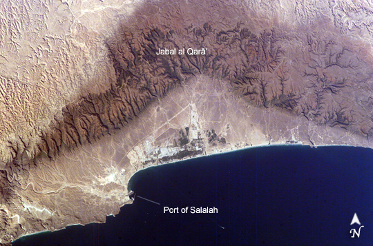 |
| Salalah, Sultanate of Oman The city of Salalah is the capitol of the Dhofar region of Oman and is known as the "perfume capitol of Arabia." The city is a popular destination for tourism due to the natural attractions of the al Qar mountains (Jabal al Qar, in Arabic) and abundant stands of frankincense trees lining mountain stream courses. These can be seen in the astronaut photograph as green regions in the Jabal al Qar north of the city (located in the center of the image). The beaches and coastline are also major attractions for scuba diving and bird watching. Salalah is a city of antiquity, boasting both the ruins of a palace reputed to have belonged to the Queen of Sheba and the resting place of the biblical prophet Job in the nearby Jabal al Qar. Modern Oman is also represented by the Port of Salalah, located approximately 15 km to the southwest of the city. The strategic location of this port has made it one of the major entry points to India, the Middle East, and Africa. The rectangular projection into the Arabian Sea visible in the astronaut photograph is a large shipping container loading/unloading platform. |
| Images: | All Available Images Low-Resolution 290k |
|
| Mission: | ISS010 |
|
| Roll - Frame: | E - 7210 |
|
| Geographical Name: | OMAN |
|
| Features: | SALALAH, AL QARA MTS., RAVINES |
|
| Center Lat x Lon: | 17.0N x 54.0E |
|
| Film Exposure: | N=Normal exposure, U=Under exposed, O=Over exposed, F=out of Focus |
|
| Percentage of Cloud Cover-CLDP: | 10 |
|
| Camera:: | E4 |
|
| Camera Tilt: | 35 | LO=Low Oblique, HO=High Oblique, NV=Near Vertical |
| Camera Focal Length: | 180 |
|
| Nadir to Photo Center Direction: | E | The direction from the nadir to the center point, N=North, S=South, E=East, W=West |
| Stereo?: | Y=Yes there is an adjacent picture of the same area, N=No there isn't |
|
| Orbit Number: | 2224 |
|
| Date: | 20041116 | YYYYMMDD |
| Time: | 113917 | GMT HHMMSS |
| Nadir Lat: | 17.1N |
Latitude of suborbital point of spacecraft |
| Nadir Lon: | 51.8E |
Longitude of suborbital point of spacecraft |
| Sun Azimuth: | 236 | Clockwise angle in degrees from north to the sun measured at the nadir point |
| Space Craft Altitude: | 188 | nautical miles |
| Sun Elevation: | 29 | Angle in degrees between the horizon and the sun, measured at the nadir point |
| Land Views: | MOUNTAIN |
|
| Water Views: | SEA |
|
| Atmosphere Views: | |
|
| Man Made Views: | PORT |
|
| City Views: | SALALAH |
|
Photo is not associated with any sequences | ||
| NASA Home Page |
JSC Home Page |
JSC Digital Image Collection |
Earth Science & Remote Sensing |
|
This service is provided by the International Space Station program and the JSC Earth Science & Remote Sensing Unit, ARES Division, Exploration Integration Science Directorate.

|