
Geographic Region: AUSTRALIA-WA
Feature: DIRK HARTOG I., USELESS INLET
|
Geographic Region: AUSTRALIA-WA Feature: DIRK HARTOG I., USELESS INLET |
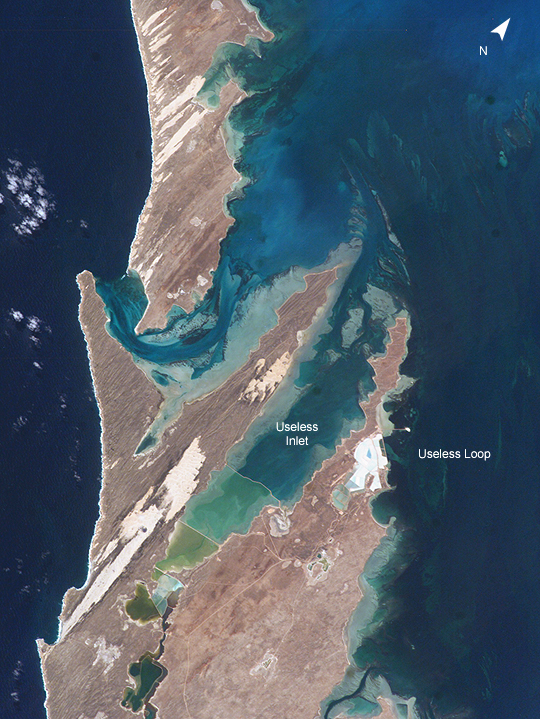 |
| Shark Bay, Australia This image shows large solar salt works developed in Useless Loop and Useless Inlet, Shark Bay, Western Australia (for a regional image of Shark Bay, see Phytoplankton in Shark Bay ). The salt (sodium chloride) is produced when ponds are repeatedly flooded with seawater, which is progressively concentrated by evaporation. This particular salt farm opened in 1967 and expanded operations in the 1990s. Today, this salt farm comprises over 50 ponds'the newest pond is the outermost pond in Useless Inlet, which provides the first evaporation cycle to increase the salinity of the water prior to entering the next pond. Complex chemical and biological adjustments occur in the system each time the configuration of ponds is changed. Solar salt production has increased along the world's arid coastal regions. Global demand for salt is on the rise, primarily because salt is a basic feedstock to the chemical industry (the largest salt consumer). Commercial solar salt ponds are frequently controversial components of coastal ecosystems. The hypersaline conditions are toxic to preexisting ecosystems in and around the converted land, and valuable coastal wetlands may be impacted by flooding, changing water levels and salinities. However, salt ponds have also been successfully converted to wetlands, and the shallow ponds can support shellfish and bird populations. |
| Images: | All Available Images Low-Resolution 499k |
|
| Mission: | ISS010 |
|
| Roll - Frame: | E - 6681 |
|
| Geographical Name: | AUSTRALIA-WA |
|
| Features: | DIRK HARTOG I., USELESS INLET |
|
| Center Lat x Lon: | 26S x 113.0E |
|
| Film Exposure: | N=Normal exposure, U=Under exposed, O=Over exposed, F=out of Focus |
|
| Percentage of Cloud Cover-CLDP: | 10 |
|
| Camera:: | E4 |
|
| Camera Tilt: | 33 | LO=Low Oblique, HO=High Oblique, NV=Near Vertical |
| Camera Focal Length: | 180 |
|
| Nadir to Photo Center Direction: | NW | The direction from the nadir to the center point, N=North, S=South, E=East, W=West |
| Stereo?: | Y=Yes there is an adjacent picture of the same area, N=No there isn't |
|
| Orbit Number: | 2157 |
|
| Date: | 20041112 | YYYYMMDD |
| Time: | 063853 | GMT HHMMSS |
| Nadir Lat: | 27.3S |
Latitude of suborbital point of spacecraft |
| Nadir Lon: | 114.6E |
Longitude of suborbital point of spacecraft |
| Sun Azimuth: | 277 | Clockwise angle in degrees from north to the sun measured at the nadir point |
| Space Craft Altitude: | 191 | nautical miles |
| Sun Elevation: | 54 | Angle in degrees between the horizon and the sun, measured at the nadir point |
| Land Views: | |
|
| Water Views: | BAY, FLOODING, INLET |
|
| Atmosphere Views: | |
|
| Man Made Views: | |
|
| City Views: | |
|
Photo is not associated with any sequences | ||
| NASA Home Page |
JSC Home Page |
JSC Digital Image Collection |
Earth Science & Remote Sensing |
|
This service is provided by the International Space Station program and the JSC Earth Science & Remote Sensing Unit, ARES Division, Exploration Integration Science Directorate.

|