Geographic Region: VENEZUELA
Feature: L. VALENCIA, MARACAY, MTS.
|
Geographic Region: VENEZUELA Feature: L. VALENCIA, MARACAY, MTS. |
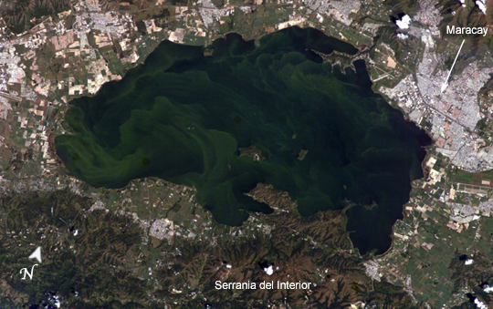 |
| Lago de Valencia (Lake Valencia) is located in north-central Venezuela and is the largest freshwater lake in the country. The lake was formed approximately 2-3 million years ago due to faulting and subsequent damming of the Valencia River. The lake has been completely dry during several discrete periods of its geologic history. Since 1976 Lake Valencia water levels have risen due to diversion of water from neighboring watersheds--it currently acts as a reservoir for the surrounding urban centers (such as Maracay). The vivid green algal blooms present in this image result from a continual influx of untreated wastewater from the surrounding urban, agricultural, and industrial land uses. This contributes to ongoing eutrophication, contamination, and salinization of the lake. Despite its picturesque location between the Cordillera de la Costa to the north and the Serrania del Interior to the south, Lake Valencia's poor water quality limits opportunities for tourism and recreational activities. |
| Images: | All Available Images Low-Resolution 250k |
|
| Mission: | ISS010 |
|
| Roll - Frame: | E - 5194 |
|
| Geographical Name: | VENEZUELA |
|
| Features: | L. VALENCIA, MARACAY, MTS. |
|
| Center Lat x Lon: | 10.0N x 67.5W |
|
| Film Exposure: | N=Normal exposure, U=Under exposed, O=Over exposed, F=out of Focus |
|
| Percentage of Cloud Cover-CLDP: | 10 |
|
| Camera:: | E4 |
|
| Camera Tilt: | 22 | LO=Low Oblique, HO=High Oblique, NV=Near Vertical |
| Camera Focal Length: | 180 |
|
| Nadir to Photo Center Direction: | N | The direction from the nadir to the center point, N=North, S=South, E=East, W=West |
| Stereo?: | Y=Yes there is an adjacent picture of the same area, N=No there isn't |
|
| Orbit Number: | 1911 |
|
| Date: | 20041027 | YYYYMMDD |
| Time: | 141506 | GMT HHMMSS |
| Nadir Lat: | 8.8N |
Latitude of suborbital point of spacecraft |
| Nadir Lon: | 66.9W |
Longitude of suborbital point of spacecraft |
| Sun Azimuth: | 127 | Clockwise angle in degrees from north to the sun measured at the nadir point |
| Space Craft Altitude: | 195 | nautical miles |
| Sun Elevation: | 54 | Angle in degrees between the horizon and the sun, measured at the nadir point |
| Land Views: | |
|
| Water Views: | LAKE, RESERVOIR, RIVER |
|
| Atmosphere Views: | |
|
| Man Made Views: | |
|
| City Views: | MARACAY |
|
Photo is not associated with any sequences | ||
| NASA Home Page |
JSC Home Page |
JSC Digital Image Collection |
Earth Science & Remote Sensing |
|
This service is provided by the International Space Station program and the JSC Earth Science & Remote Sensing Unit, ARES Division, Exploration Integration Science Directorate.

|