
Geographic Region: USA-MICHIGAN
Feature: STR. OF MACKINAC, GLINT, ICE
|
Geographic Region: USA-MICHIGAN Feature: STR. OF MACKINAC, GLINT, ICE |
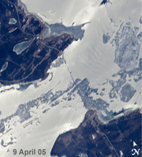 |
| Spring Thaw, Straits of Mackinac The Mackinac Bridge spans a stretch of water five miles wide between Michigan's lower and upper peninsulas. The strait connects Lakes Michigan (left) and Huron (right). The bridge is a combination of pier-supported spans with a high, central suspension sector that allows passage of lake steamers. The suspension sector is the longest in the Americas (8, 614 feet or 1.6 miles). Prior to construction of the bridge, the only passage across the straits was by ferryboat. This pair of images shows the Mackinac Straits while they were still frozen (top) and as they began to thaw (below). The March 22 view shows shipping lanes opened by ice breakers. A narrow passage connects the cleared shipping channel to the small town of St. Ignace at the north end of the bridge (Mackinaw City appears at the south end). The April view shows the ice broken into a series of irregular rafts that appear gray against bright water. The whitish appearance of the water is not snow or ice, but instead is sunlight glinting off the water back to camera. The shipping channel is maintained even through remnants of the ice mass, but the ice ridges can be hazardous to shipping until the last of the ice breaks up. |
| Images: | All Available Images Low-Resolution 210k |
|
| Mission: | ISS010 |
|
| Roll - Frame: | E - 23748 |
|
| Geographical Name: | USA-MICHIGAN |
|
| Features: | STR. OF MACKINAC, GLINT, ICE |
|
| Center Lat x Lon: | 46.0N x 85W |
|
| Film Exposure: | N=Normal exposure, U=Under exposed, O=Over exposed, F=out of Focus |
|
| Percentage of Cloud Cover-CLDP: | 10 |
|
| Camera:: | E4 |
|
| Camera Tilt: | 33 | LO=Low Oblique, HO=High Oblique, NV=Near Vertical |
| Camera Focal Length: | 180 |
|
| Nadir to Photo Center Direction: | SW | The direction from the nadir to the center point, N=North, S=South, E=East, W=West |
| Stereo?: | Y=Yes there is an adjacent picture of the same area, N=No there isn't |
|
| Orbit Number: | 491 |
|
| Date: | 20050409 | YYYYMMDD |
| Time: | 170850 | GMT HHMMSS |
| Nadir Lat: | 47.8N |
Latitude of suborbital point of spacecraft |
| Nadir Lon: | 84W |
Longitude of suborbital point of spacecraft |
| Sun Azimuth: | 169 | Clockwise angle in degrees from north to the sun measured at the nadir point |
| Space Craft Altitude: | 190 | nautical miles |
| Sun Elevation: | 50 | Angle in degrees between the horizon and the sun, measured at the nadir point |
| Land Views: | |
|
| Water Views: | CHANNEL, ICE, LAKE, STRAIT |
|
| Atmosphere Views: | |
|
| Man Made Views: | BRIDGE |
|
| City Views: | MACKINAW CITY |
|
Photo is not associated with any sequences | ||
| NASA Home Page |
JSC Home Page |
JSC Digital Image Collection |
Earth Science & Remote Sensing |
|
This service is provided by the International Space Station program and the JSC Earth Science & Remote Sensing Unit, ARES Division, Exploration Integration Science Directorate.

|