
Geographic Region: SUDAN
Feature: WHITE NILE,BLUE NILE, KHARTOUM
|
Geographic Region: SUDAN Feature: WHITE NILE,BLUE NILE, KHARTOUM |
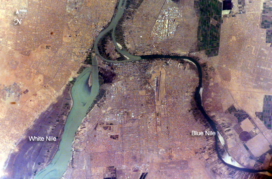 |
| Khartoum, Sudan Sudan's capital city, Khartoum, translates as "Elephant's Trunk." The name describes the shape of the Nile where the Blue and the White Nile Rivers unite to form the single Nile River that flows northward into Egypt. This image shows the rivers near the end of the dry season. The White Nile (western branch) runs through Sudan from Uganda. The White Nile originates in equatorial regions, where rainfall occurs throughout the year; as a result, it runs at a nearly constant rate throughout the year. The Blue Nile, nearly dry this time of year, flows out of the Ethiopian highlands, where rainfall is more seasonal. The Blue Nile swells in the late summer and early fall with rains from the summer monsoons. The flow at these times can be so great that the volume is too much for the river's channel, causing the Nile to flow backward at the junction. In recent years, floods in Khartoum have occurred in August with heavy monsoon rainfall. Khartoum is one of the largest Muslim cities in North Africa, but it has a fairly short history. Founded as a military outpost in 1821, a Sudanese flag has only flown over the city since 1956. Today, Khartoum is home to more than a million people, including many refugees, both from neighboring countries as well as from an ongoing civil war in southern Sudan. The city has a low profile, dominated by sprawling areas of small buildings that are supported by little infrastructure. |
| Images: | All Available Images Low-Resolution 322k |
|
| Mission: | ISS010 |
|
| Roll - Frame: | E - 23451 |
|
| Geographical Name: | SUDAN |
|
| Features: | WHITE NILE,BLUE NILE, KHARTOUM |
|
| Center Lat x Lon: | 15.6N x 32.5E |
|
| Film Exposure: | N=Normal exposure, U=Under exposed, O=Over exposed, F=out of Focus |
|
| Percentage of Cloud Cover-CLDP: | 10 |
|
| Camera:: | E4 |
|
| Camera Tilt: | 37 | LO=Low Oblique, HO=High Oblique, NV=Near Vertical |
| Camera Focal Length: | 400 |
|
| Nadir to Photo Center Direction: | NW | The direction from the nadir to the center point, N=North, S=South, E=East, W=West |
| Stereo?: | Y=Yes there is an adjacent picture of the same area, N=No there isn't |
|
| Orbit Number: | 457 |
|
| Date: | 20050407 | YYYYMMDD |
| Time: | 132740 | GMT HHMMSS |
| Nadir Lat: | 13.5N |
Latitude of suborbital point of spacecraft |
| Nadir Lon: | 33.7E |
Longitude of suborbital point of spacecraft |
| Sun Azimuth: | 269 | Clockwise angle in degrees from north to the sun measured at the nadir point |
| Space Craft Altitude: | 194 | nautical miles |
| Sun Elevation: | 36 | Angle in degrees between the horizon and the sun, measured at the nadir point |
| Land Views: | |
|
| Water Views: | CHANNEL, RIVER |
|
| Atmosphere Views: | |
|
| Man Made Views: | |
|
| City Views: | KHARTOUM |
|
Photo is not associated with any sequences | ||
| NASA Home Page |
JSC Home Page |
JSC Digital Image Collection |
Earth Science & Remote Sensing |
|
This service is provided by the International Space Station program and the JSC Earth Science & Remote Sensing Unit, ARES Division, Exploration Integration Science Directorate.

|