
Geographic Region: USA-FLORIDA
Feature: LAUNCH COMPLEXES, FALSE CAPE
|
Geographic Region: USA-FLORIDA Feature: LAUNCH COMPLEXES, FALSE CAPE |
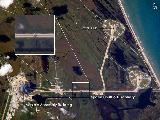 |
| Rollout of Shuttle Discovery, Kennedy Space Center International Space Station Astronaut Leroy Chiao, like the rest of NASA, tracks key milestones for the Space Shuttle Return-to-Flight operations. A lucky overpass of the Space Station over Florida on April 6, 2005, allowed Leroy and his crew mate Salizhan Sharipov a unique view of the rollout of the Space Shuttle Discovery. At the time of his observations, Discovery was approximately midway between the Vehicle Assembly Building (VAB) and launch pad 39-B at Kennedy Space Center in Florida. The Shuttle, mated with its solid-fuel booster rockets and orange external fuel tank, is visible on the wide Crawler-Transporter track (marked with white box and shown in an inset image). Moving at a maximum speed of 1 mile per hour (1.6 km/hr), the massive Crawler-Transporter, laden with a launch-configured Shuttle and Mobile Launch Platform, takes approximately 13 hours to move between the VAB and pad 39-B. Launch of the Discovery will mark NASA's "Return to Flight" following the loss of the Shuttle Columbia with its crew on February 1, 2003. The primary goal for the upcoming Discovery mission will be to test several vehicle modifications and damage-assessment data sources, tools, and procedures. These modifications include a modified design for the external fuel tank, more cameras focused on the launch and ascent of the Shuttle, and detailed imaging of the Shuttle's heat-resistant tiles and reinforced carbon-carbon surfaces on the wings and nosecap. |
| Images: | All Available Images Low-Resolution 80k |
|
| Mission: | ISS010 |
|
| Roll - Frame: | E - 23035 |
|
| Geographical Name: | USA-FLORIDA |
|
| Features: | LAUNCH COMPLEXES, FALSE CAPE |
|
| Center Lat x Lon: | 28.6N x 80.6W |
|
| Film Exposure: | N=Normal exposure, U=Under exposed, O=Over exposed, F=out of Focus |
|
| Percentage of Cloud Cover-CLDP: | 10 |
|
| Camera:: | E4 |
|
| Camera Tilt: | 46 | LO=Low Oblique, HO=High Oblique, NV=Near Vertical |
| Camera Focal Length: | 800 |
|
| Nadir to Photo Center Direction: | N | The direction from the nadir to the center point, N=North, S=South, E=East, W=West |
| Stereo?: | Y=Yes there is an adjacent picture of the same area, N=No there isn't |
|
| Orbit Number: | 446 |
|
| Date: | 20050406 | YYYYMMDD |
| Time: | 203601 | GMT HHMMSS |
| Nadir Lat: | 25.3N |
Latitude of suborbital point of spacecraft |
| Nadir Lon: | 80.1W |
Longitude of suborbital point of spacecraft |
| Sun Azimuth: | 257 | Clockwise angle in degrees from north to the sun measured at the nadir point |
| Space Craft Altitude: | 193 | nautical miles |
| Sun Elevation: | 40 | Angle in degrees between the horizon and the sun, measured at the nadir point |
| Land Views: | |
|
| Water Views: | |
|
| Atmosphere Views: | |
|
| Man Made Views: | |
|
| City Views: | COLUMBIA, MOBILE |
|
Photo is not associated with any sequences | ||
| NASA Home Page |
JSC Home Page |
JSC Digital Image Collection |
Earth Science & Remote Sensing |
|
This service is provided by the International Space Station program and the JSC Earth Science & Remote Sensing Unit, ARES Division, Exploration Integration Science Directorate.

|