
Geographic Region: PERU
Feature: LIMA,PARK VEGETATION
|
Geographic Region: PERU Feature: LIMA,PARK VEGETATION |
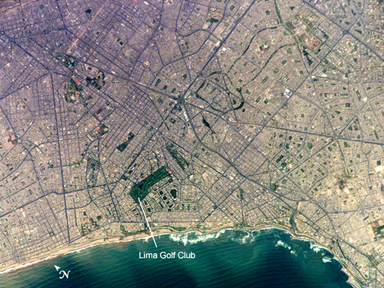 |
| Lima Metropolitan Area, Peru Located on the broad alluvial fan of the Rimac River, Lima is the capital of Peru and the only megacity (7.7 million inhabitants in 2002) located on the western coastline of South America. The city was established by Francisco Pizarro in 1535 and became an important colonial port, linking silver mines of the Altiplano of the high Andes Mountains with the burgeoning Spanish empire. During the mid-20th century, significant numbers of people relocated from rural mountain communities into the Lima metropolitan area. Problems now facing the metropolitan region include developing adequate water resources, controlling pollution, and preparing for natural hazards such as earthquakes and landslides. This astronaut photograph depicts the wealthier San Isidro and Miraflores quarters of Lima. This part of the metropolitan area is characterized by numerous vegetated parks, golf courses (such as the Lima Golf Course--approximately 1 km long), and greenbelts interspersed with residential and commercial areas. The higher proportion of dark asphalt in the street grid of the residential and commercial areas lends a purple coloration to the left portion of the astronaut photograph (downtown Lima is to the north). Regions with fewer built materials and vegetation are light tan. Wave patterns are visible approaching beaches, popular tourist destinations, in the lower half of the image. |
| Images: | Images: | NO IMAGES YET | |||
| Mission: | ISS010 |
||||
| Roll - Frame: | E - 20111 |
||||
| Geographical Name: | PERU |
||||
| Features: | LIMA,PARK VEGETATION |
||||
| Center Lat x Lon: | 12.1S x 77W |
||||
| Film Exposure: | N=Normal exposure, U=Under exposed, O=Over exposed, F=out of Focus |
||||
| Percentage of Cloud Cover-CLDP: | 10 |
||||
| Camera:: | E4 |
||||
| Camera Tilt: | 22 | LO=Low Oblique, HO=High Oblique, NV=Near Vertical |
|||
| Camera Focal Length: | 800 |
||||
| Nadir to Photo Center Direction: | S | The direction from the nadir to the center point, N=North, S=South, E=East, W=West |
|||
| Stereo?: | Y=Yes there is an adjacent picture of the same area, N=No there isn't |
||||
| Orbit Number: | 129 |
||||
| Date: | 20050317 | YYYYMMDD |
|||
| Time: | 172459 | GMT HHMMSS |
|||
| Nadir Lat: | 10.9S |
Latitude of suborbital point of spacecraft | |||
| Nadir Lon: | 76.5W |
Longitude of suborbital point of spacecraft | |||
| Sun Azimuth: | 345 | Clockwise angle in degrees from north to the sun measured at the nadir point |
|||
| Space Craft Altitude: | 194 | nautical miles |
|||
| Sun Elevation: | 80 | Angle in degrees between the horizon and the sun, measured at the nadir point |
|||
| Land Views: | ALLUVIAL FAN, MOUNTAIN |
||||
| Water Views: | RIVER, WAVE |
||||
| Atmosphere Views: | |
||||
| Man Made Views: | POLLUTION, PORT |
||||
| City Views: | LIMA |
||||
Photo is not associated with any sequences | |||||
| NASA Home Page |
JSC Home Page |
JSC Digital Image Collection |
Earth Science & Remote Sensing |
|
This service is provided by the International Space Station program and the JSC Earth Science & Remote Sensing Unit, ARES Division, Exploration Integration Science Directorate.

|