Geographic Region: ALGERIA
Feature: ISSAOUANE SAND SEA, STAR DUNES
|
Geographic Region: ALGERIA Feature: ISSAOUANE SAND SEA, STAR DUNES |
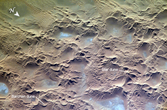 |
| Issaouane Erg, Algeria The Issaouane Erg (sand sea) is located in eastern Algeria between the Tinrhert Plateau to the north and the Fadnoun Plateau to the south. Ergs are vast areas of moving sand with little to no vegetation cover. Considered to be part of the Sahara Desert, the Issaouane Erg covers an area of approximately 38,000 km2. These complex dunes form the active southwestern border of the sand sea. The most common landforms in the image are star dunes and barchan (or crescent) dunes. Small linear dunes appear at top left. Star dunes are formed when sand is transported from variable wind directions, whereas barchan dunes form in a single dominant wind regime. The superimposition of two dune types suggests that wind regimes have changed through time. The active nature of this portion of the Erg is well illustrated by this image--smaller dunes form and migrate along the flanks of the larger dunes and sand ridges. Occasional precipitation fills basins formed by the dunes; as the water evaporates, salt deposits are left behind which appear as bluish-white areas. |
| Images: | All Available Images Low-Resolution 302k |
|
| Mission: | ISS010 |
|
| Roll - Frame: | E - 13539 |
|
| Geographical Name: | ALGERIA |
|
| Features: | ISSAOUANE SAND SEA, STAR DUNES |
|
| Center Lat x Lon: | 26.8N x 7.3E |
|
| Film Exposure: | N=Normal exposure, U=Under exposed, O=Over exposed, F=out of Focus |
|
| Percentage of Cloud Cover-CLDP: | 0 |
|
| Camera:: | E4 |
|
| Camera Tilt: | HO | LO=Low Oblique, HO=High Oblique, NV=Near Vertical |
| Camera Focal Length: | 800 |
|
| Nadir to Photo Center Direction: | SW | The direction from the nadir to the center point, N=North, S=South, E=East, W=West |
| Stereo?: | Y=Yes there is an adjacent picture of the same area, N=No there isn't |
|
| Orbit Number: | 3185 |
|
| Date: | 20050116 | YYYYMMDD |
| Time: | 142512 | GMT HHMMSS |
| Nadir Lat: | 36.7N |
Latitude of suborbital point of spacecraft |
| Nadir Lon: | 19.4E |
Longitude of suborbital point of spacecraft |
| Sun Azimuth: | 230 | Clockwise angle in degrees from north to the sun measured at the nadir point |
| Space Craft Altitude: | 188 | nautical miles |
| Sun Elevation: | 14 | Angle in degrees between the horizon and the sun, measured at the nadir point |
| Land Views: | DESERT, DUNE, PLATEAU |
|
| Water Views: | SEA |
|
| Atmosphere Views: | |
|
| Man Made Views: | |
|
| City Views: | |
|
Photo is not associated with any sequences | ||
| NASA Home Page |
JSC Home Page |
JSC Digital Image Collection |
Earth Science & Remote Sensing |
|
This service is provided by the International Space Station program and the JSC Earth Science & Remote Sensing Unit, ARES Division, Exploration Integration Science Directorate.

|