Geographic Region: SOUTH KOREA
Feature: SEOUL AT NIGHT
|
Geographic Region: SOUTH KOREA Feature: SEOUL AT NIGHT |
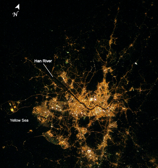 |
| Seoul, South Korea The city of Seoul (originally known as Hanyang) has been the capitol of Korea for more than 600 years. It became the capitol of South Korea as part of that country's independence. Despite this long history, Seoul is a thoroughly modern megacity that has a population of over 10 million people. As the dominant (or "primate") city in South Korea, Seoul is a major force in regional politics, finance, culture, and education. This astronaut photograph illustrates the Seoul urban area at night. Major roadways and river courses (such as the Han River) are clearly outlined by street lights, while the brightest lights indicate the downtown urban core (center of image) and large industrial complexes. One such complex is located at the far left of the image and occupies an island in the Yellow Sea. Very dark regions in the image are mountains or large bodies of water. Nighttime images have been used extensively in urban climate and urban growth research to map the extent of urban (bright) versus rural (dark) regions. |
| Images: | All Available Images Low-Resolution 289k |
|
| Mission: | ISS010 |
|
| Roll - Frame: | E - 12103 |
|
| Geographical Name: | SOUTH KOREA |
|
| Features: | SEOUL AT NIGHT |
|
| Center Lat x Lon: | 37.5N x 127.0E |
|
| Film Exposure: | N=Normal exposure, U=Under exposed, O=Over exposed, F=out of Focus |
|
| Percentage of Cloud Cover-CLDP: | 10 |
|
| Camera:: | N1 |
|
| Camera Tilt: | HO | LO=Low Oblique, HO=High Oblique, NV=Near Vertical |
| Camera Focal Length: | 58 |
|
| Nadir to Photo Center Direction: | W | The direction from the nadir to the center point, N=North, S=South, E=East, W=West |
| Stereo?: | Y=Yes there is an adjacent picture of the same area, N=No there isn't |
|
| Orbit Number: | 2840 |
|
| Date: | 20041225 | YYYYMMDD |
| Time: | 161628 | GMT HHMMSS |
| Nadir Lat: | 48.2N |
Latitude of suborbital point of spacecraft |
| Nadir Lon: | 151.3E |
Longitude of suborbital point of spacecraft |
| Sun Azimuth: | 61 | Clockwise angle in degrees from north to the sun measured at the nadir point |
| Space Craft Altitude: | 187 | nautical miles |
| Sun Elevation: | -53 | Angle in degrees between the horizon and the sun, measured at the nadir point |
| Land Views: | ISLAND |
|
| Water Views: | RIVER, SEA |
|
| Atmosphere Views: | |
|
| Man Made Views: | URBAN AREA |
|
| City Views: | SEOUL |
|
Photo is not associated with any sequences | ||
| NASA Home Page |
JSC Home Page |
JSC Digital Image Collection |
Earth Science & Remote Sensing |
|
This service is provided by the International Space Station program and the JSC Earth Science & Remote Sensing Unit, ARES Division, Exploration Integration Science Directorate.

|