 Photo #: ISS009-E-20909 Date: Aug. 2004
Geographic Region: ATLANTIC OCEAN
Feature: PAN-HURRICANE FRANCES, BANDS
|
Photo #: ISS009-E-20909 Date: Aug. 2004 Geographic Region: ATLANTIC OCEAN Feature: PAN-HURRICANE FRANCES, BANDS |
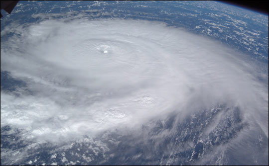 |
| This image of Hurricane Frances was acquired by the crew of the International Space Station early on August 30 as the storm was moving westward some 265 miles east-northeast of the northern Windward Islands. The storm was packing winds of 120 miles per hour at the time and appeared to be tracking towards the Bahamas Islands and eventually Florida. A large, ragged eye is visible with a large arc of high clouds flowing away from the top of the storm. |
| Images: | All Available Images Low-Resolution 28k |
|
| Mission: | ISS009 |
|
| Roll - Frame: | E - 20909 |
|
| Geographical Name: | ATLANTIC OCEAN |
|
| Features: | PAN-HURRICANE FRANCES, BANDS |
|
| Center Lat x Lon: | 19.2N x 58.1W |
|
| Film Exposure: | N=Normal exposure, U=Under exposed, O=Over exposed, F=out of Focus |
|
| Percentage of Cloud Cover-CLDP: | 100 |
|
| Camera:: | E4 |
|
| Camera Tilt: | HO | LO=Low Oblique, HO=High Oblique, NV=Near Vertical |
| Camera Focal Length: | 26 |
|
| Nadir to Photo Center Direction: | W | The direction from the nadir to the center point, N=North, S=South, E=East, W=West |
| Stereo?: | Y=Yes there is an adjacent picture of the same area, N=No there isn't |
|
| Orbit Number: | 999 |
|
| Date: | 20040830 | YYYYMMDD |
| Time: | 121647 | GMT HHMMSS |
| Nadir Lat: | 18.7N |
Latitude of suborbital point of spacecraft |
| Nadir Lon: | 52.3W |
Longitude of suborbital point of spacecraft |
| Sun Azimuth: | 95 | Clockwise angle in degrees from north to the sun measured at the nadir point |
| Space Craft Altitude: | 193 | nautical miles |
| Sun Elevation: | 42 | Angle in degrees between the horizon and the sun, measured at the nadir point |
| Land Views: | |
|
| Water Views: | |
|
| Atmosphere Views: | HURRICANE |
|
| Man Made Views: | |
|
| City Views: | |
|
Photo is not associated with any sequences | ||
| NASA Home Page |
JSC Home Page |
JSC Digital Image Collection |
Earth Science & Remote Sensing |
|
This service is provided by the International Space Station program and the JSC Earth Science & Remote Sensing Unit, ARES Division, Exploration Integration Science Directorate.

|