Geographic Region: BRAZIL
Feature: MANAUS, AMAZON NEGRO CONFLUEN
|
Geographic Region: BRAZIL Feature: MANAUS, AMAZON NEGRO CONFLUEN |
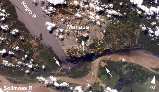 |
| Solimoes-Negro River Confluence at Manaus, Amazonia The largest river on the planet, the Amazon, forms from the confluence of the Solimoes (the upper Amazon River) and the Negro at the Brazilian city of Manaus in central Amazonas. At the river conjunction, the muddy, tan-colored waters of the Solimoes meet the "black" water of the Negro River. The unique mixing zone where the waters meet extends downstream through the rainforest for hundreds of kilometers, and is a famous attraction for tourists from all over the world. The tourism contributes to substantial growth in the city of Manaus. Twenty years ago the large park near the city center (center) lay on the eastern outskirts of Manaus. It is the vast quantity of sediment eroded from the Andes Mountains that gives the Solimoes its tan color. By comparison, water in the Negro derives from the low jungles where reduced physical erosion of rock precludes mud entering the river. In place of sediment, organic matter from the forest floor stains the river the color of black tea. The Solimoes provides nutrient-rich mud to lakes on the floodplain (lower right). The ecology of muddy lakes differs correspondingly from that of nutrient-poor, blackwater rivers and lakes. Solimoes water can be seen leaking into the Negro west of the main meeting zone (lower left). The Solimoes is much shallower than the Negro because it has filled its valley and bed with great quantities of sediment since the valleys were excavated. Indeed, widths of the rivers differ for this reason (the Negro River is almost 20 km wide in the top left corner). |
| Images: | All Available Images Low-Resolution 241k |
|
| Mission: | ISS009 |
|
| Roll - Frame: | E - 15488 |
|
| Geographical Name: | BRAZIL |
|
| Features: | MANAUS, AMAZON NEGRO CONFLUEN |
|
| Center Lat x Lon: | 3S x 60W |
|
| Film Exposure: | N=Normal exposure, U=Under exposed, O=Over exposed, F=out of Focus |
|
| Percentage of Cloud Cover-CLDP: | 25 |
|
| Camera:: | E4 |
|
| Camera Tilt: | 24 | LO=Low Oblique, HO=High Oblique, NV=Near Vertical |
| Camera Focal Length: | 180 |
|
| Nadir to Photo Center Direction: | W | The direction from the nadir to the center point, N=North, S=South, E=East, W=West |
| Stereo?: | Y=Yes there is an adjacent picture of the same area, N=No there isn't |
|
| Orbit Number: | 358 |
|
| Date: | 20040720 | YYYYMMDD |
| Time: | 180740 | GMT HHMMSS |
| Nadir Lat: | 3S |
Latitude of suborbital point of spacecraft |
| Nadir Lon: | 58.6W |
Longitude of suborbital point of spacecraft |
| Sun Azimuth: | 308 | Clockwise angle in degrees from north to the sun measured at the nadir point |
| Space Craft Altitude: | 192 | nautical miles |
| Sun Elevation: | 51 | Angle in degrees between the horizon and the sun, measured at the nadir point |
| Land Views: | EROSION, FOREST, VALLEY |
|
| Water Views: | RIVER, SEDIMENT |
|
| Atmosphere Views: | |
|
| Man Made Views: | |
|
| City Views: | MANAUS |
|
Photo is not associated with any sequences | ||
| NASA Home Page |
JSC Home Page |
JSC Digital Image Collection |
Earth Science & Remote Sensing |
|
This service is provided by the International Space Station program and the JSC Earth Science & Remote Sensing Unit, ARES Division, Exploration Integration Science Directorate.

|