
Geographic Region: RUSSIAN FEDERATION
Feature: NALCHIK, FOREST, AIRPORT, AGRICULTURE
|
Geographic Region: RUSSIAN FEDERATION Feature: NALCHIK, FOREST, AIRPORT, AGRICULTURE |
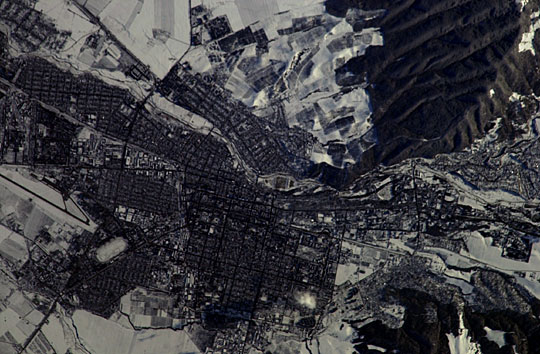 |
| Nalchik, Caucasus Mts., Russian Federation: This winter-time view of the city of Nalchik on the north slopes of the Greater Caucasus Mountains, was taken with a handheld camera from the International Space Station in early 2004. Rectangles are the city blocks of Nalchik (population ~240,000), a city which lies where the major Terek River exits from the mountains. The river appears as a meandering line crossing the view, slightly diagonally from right to left. Dark forests (top right and lower right) make the mountain sides appear snow free. A dark line, probably a major canal, crosses the view to the lower left corner. Nalchik is a tourist resort and industrial center. It is the major city of the Kabardino-Balkar Republic (population ~ 750,000), one of five small republics on the north slopes of the Caucasus Mountains, 200 km west of Chechnya. |
| Images: | All Available Images Low-Resolution 72k |
|
| Mission: | ISS008 |
|
| Roll - Frame: | E - 9610 |
|
| Geographical Name: | RUSSIAN FEDERATION |
|
| Features: | NALCHIK, FOREST, AIRPORT, AGRICULTURE |
|
| Center Lat x Lon: | 43.5N x 43.5E |
|
| Film Exposure: | N=Normal exposure, U=Under exposed, O=Over exposed, F=out of Focus |
|
| Percentage of Cloud Cover-CLDP: | 10 |
|
| Camera:: | N1 |
|
| Camera Tilt: | 36 | LO=Low Oblique, HO=High Oblique, NV=Near Vertical |
| Camera Focal Length: | 800 |
|
| Nadir to Photo Center Direction: | W | The direction from the nadir to the center point, N=North, S=South, E=East, W=West |
| Stereo?: | Y=Yes there is an adjacent picture of the same area, N=No there isn't |
|
| Orbit Number: | 1012 |
|
| Date: | 20031220 | YYYYMMDD |
| Time: | 103617 | GMT HHMMSS |
| Nadir Lat: | 42.7N |
Latitude of suborbital point of spacecraft |
| Nadir Lon: | 45.8E |
Longitude of suborbital point of spacecraft |
| Sun Azimuth: | 205 | Clockwise angle in degrees from north to the sun measured at the nadir point |
| Space Craft Altitude: | 199 | nautical miles |
| Sun Elevation: | 20 | Angle in degrees between the horizon and the sun, measured at the nadir point |
| Land Views: | MOUNTAIN |
|
| Water Views: | CANAL, RIVER |
|
| Atmosphere Views: | |
|
| Man Made Views: | |
|
| City Views: | |
|
Photo is not associated with any sequences | ||
| NASA Home Page |
JSC Home Page |
JSC Digital Image Collection |
Earth Science & Remote Sensing |
|
This service is provided by the International Space Station program and the JSC Earth Science & Remote Sensing Unit, ARES Division, Exploration Integration Science Directorate.

|