
Geographic Region: ATLANTIC OCEAN
Feature: PLANKTON BLOOM, POINT DEL ESTE
|
Geographic Region: ATLANTIC OCEAN Feature: PLANKTON BLOOM, POINT DEL ESTE |
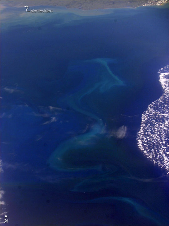 |
| The South Atlantic Ocean off the coast of Argentina and Uruguay is a rich mixing bowl of different water masses. The nutrient-rich waters from the combined Parana and Uruguay Rivers empty into the South Atlantic through the Rio de la Plata. Under the right conditions, especially in spring and early summer, the nutrients fertilize the offshore surface waters allowing for large plankton blooms. This unique image captures traces of several different water masses just southeast of Montevideo, Uruguay, and the Rio de la Plata. Close to the coast of Uruguay, the muddy fresh water plume snakes along the coast. Farther offshore, broad swirls of light blue-green and darker water mark a bloom of plankton. To the right, deep blue water covered by puffy clouds suggests another, warmer water mass just north of the bloom. The patterns of the interfaces between these water masses is complicated and dynamic. One of the objectives of International Space Station crew members is to document regions of plankton blooms. These images can be combined with other data sources such as the Sea-viewing Wide Field-of-view Sensor (SeaWiFS) and the Moderate Resolution Imaging Spectroradiometer (MODIS). Space Shuttle and International Space Station photographs frequently supply higher levels of detail than satellite imagery because the astronauts use cameras equipped with long telescopic lenses. In this case, the image is oblique (the spacecraft was approximately 45 degrees south), so exact field-of-view and resolution determinations are difficult. However, we estimate the resolution of the near part of the bloom to be between 50 to 100 meters per pixel. If a station crew can capture blooms on successive days or weeks, scientists may be able to determine something about the finer structure of the interacting water masses, the conditions necessary for blooms, and the evolution of the blooms over time. |
| Images: | All Available Images Low-Resolution 51k |
|
| Mission: | ISS008 |
|
| Roll - Frame: | E - 6009 |
|
| Geographical Name: | ATLANTIC OCEAN |
|
| Features: | PLANKTON BLOOM, POINT DEL ESTE |
|
| Center Lat x Lon: | 35.5S x 52.5W |
|
| Film Exposure: | N=Normal exposure, U=Under exposed, O=Over exposed, F=out of Focus |
|
| Percentage of Cloud Cover-CLDP: | 25 |
|
| Camera:: | E4 |
|
| Camera Tilt: | LO | LO=Low Oblique, HO=High Oblique, NV=Near Vertical |
| Camera Focal Length: | 80 |
|
| Nadir to Photo Center Direction: | The direction from the nadir to the center point, N=North, S=South, E=East, W=West |
|
| Stereo?: | Y=Yes there is an adjacent picture of the same area, N=No there isn't |
|
| Orbit Number: | |
|
| Date: | 20031114 | YYYYMMDD |
| Time: | 13____ | GMT HHMMSS |
| Nadir Lat: | N |
Latitude of suborbital point of spacecraft |
| Nadir Lon: | E |
Longitude of suborbital point of spacecraft |
| Sun Azimuth: | Clockwise angle in degrees from north to the sun measured at the nadir point |
|
| Space Craft Altitude: | nautical miles |
|
| Sun Elevation: | Angle in degrees between the horizon and the sun, measured at the nadir point |
|
| Land Views: | COAST |
|
| Water Views: | OCEAN |
|
| Atmosphere Views: | PLUME |
|
| Man Made Views: | |
|
| City Views: | MONTEVIDEO |
|
Photo is not associated with any sequences | ||
| NASA Home Page |
JSC Home Page |
JSC Digital Image Collection |
Earth Science & Remote Sensing |
|
This service is provided by the International Space Station program and the JSC Earth Science & Remote Sensing Unit, ARES Division, Exploration Integration Science Directorate.

|