
Geographic Region: PERU
Feature: LAKE TITICACA, AMANTANI ISLAND
|
Geographic Region: PERU Feature: LAKE TITICACA, AMANTANI ISLAND |
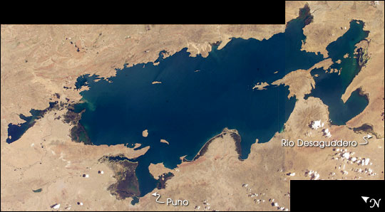 |
| Lake Titicaca: Lake Titicaca, at an elevation of 12,507 feet (3,812 meters) in the Andean Altiplano, is the highest large lake in the world. More than 120 miles long and 50 miles wide, it was the center of the Incan civilization, and today straddles the boundary between Peru and Bolivia. Perhaps more importantly, Lake Titicaca contains one of South America's longest climate records, extending back more than 25,000 years. Scientists have studied indicators of the water level changes over time in Lake Titicaca to tease out information about precipitation shifts in the high Andes and the South American tropics. Because the lake occupies the low point of the Altiplano, much of the water of the high plateau eventually trickles into the lake. And because it is surrounded by mountains, very little of Lake Titicaca's water drains out--the Rio Desguadero is the only major outflow river. So, like a bathtub with no drain, this large and deep lake (with depths of several hundred feet) has become the collecting basin for more than 25,000 years of sediment. These sediments and their fossils contain clues about past climate conditions. The restricted outflow of the lake creates conditions where even shorter, interannual climate cycles (like El Nino/Southern Oscillation) impact Lake Titicaca's water levels. Recent lake level variations have been several meters, with low levels occurring during regional droughts of El Ninos. Right now, the region is relatively wet. In this image, the dark greens of the wetlands along the shallower margins of the lake contrast strongly with the surrounding desert, while large cities like Puno, Peru (100,000 people), are difficult to discern from the surrounding countryside. |
| Images: | All Available Images Low-Resolution 43k |
|
| Mission: | ISS008 |
|
| Roll - Frame: | E - 5649 |
|
| Geographical Name: | PERU |
|
| Features: | LAKE TITICACA, AMANTANI ISLAND |
|
| Center Lat x Lon: | 15.5S x 69.5W |
|
| Film Exposure: | N=Normal exposure, U=Under exposed, O=Over exposed, F=out of Focus |
|
| Percentage of Cloud Cover-CLDP: | 10 |
|
| Camera:: | E4 |
|
| Camera Tilt: | HO | LO=Low Oblique, HO=High Oblique, NV=Near Vertical |
| Camera Focal Length: | 80 |
|
| Nadir to Photo Center Direction: | SE | The direction from the nadir to the center point, N=North, S=South, E=East, W=West |
| Stereo?: | Y=Yes there is an adjacent picture of the same area, N=No there isn't |
|
| Orbit Number: | 357 |
|
| Date: | 20031108 | YYYYMMDD |
| Time: | 145807 | GMT HHMMSS |
| Nadir Lat: | 1.2S |
Latitude of suborbital point of spacecraft |
| Nadir Lon: | 78.9W |
Longitude of suborbital point of spacecraft |
| Sun Azimuth: | 119 | Clockwise angle in degrees from north to the sun measured at the nadir point |
| Space Craft Altitude: | 203 | nautical miles |
| Sun Elevation: | 56 | Angle in degrees between the horizon and the sun, measured at the nadir point |
| Land Views: | BASIN, DESERT, PLATEAU |
|
| Water Views: | LAKE, RIVER, SEDIMENT |
|
| Atmosphere Views: | |
|
| Man Made Views: | |
|
| City Views: | |
|
Photo is not associated with any sequences | ||
| NASA Home Page |
JSC Home Page |
JSC Digital Image Collection |
Earth Science & Remote Sensing |
|
This service is provided by the International Space Station program and the JSC Earth Science & Remote Sensing Unit, ARES Division, Exploration Integration Science Directorate.

|