
Geographic Region: USA-CALIFORNIA
Feature: SMOG, LOWER SAN JOAQUIN VALLEY
|
Geographic Region: USA-CALIFORNIA Feature: SMOG, LOWER SAN JOAQUIN VALLEY |
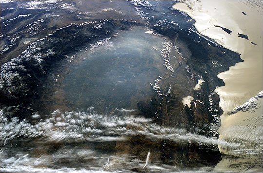 |
| The smoky remnants of October's devastating fires still filled the southern California Central Valley on November 2, 2003. This "upside down" digital photograph was taken from the International Space Station from a position over the Pacific Northwest looking southward toward southern California. At the time this image was acquired, the fires had finally been brought under control, but ash and smoke remained trapped in the atmosphere above the valley, a bowl of land ringed by the Sierra Nevada Mountains to the east (left) and the Coast Range Mountains to the west (right). The band of clouds at the bottom of the image is at an altitude above the mountains. The amber color in the sunglint over the Pacific coastal waters (right) also indicates the presence of smoke. At the top center of the image, the Mojave Desert comes to a point at the southern end of the Central Valley. This image is part of a series of images of the California fires taken by the ISS crew. Just a week earlier, the astronauts observed and documented the California fires at their worst. |
| Images: | All Available Images Low-Resolution 63k |
|
| Mission: | ISS008 |
|
| Roll - Frame: | E - 5095 |
|
| Geographical Name: | USA-CALIFORNIA |
|
| Features: | SMOG, LOWER SAN JOAQUIN VALLEY |
|
| Center Lat x Lon: | 36.5N x 119.5W |
|
| Film Exposure: | N=Normal exposure, U=Under exposed, O=Over exposed, F=out of Focus |
|
| Percentage of Cloud Cover-CLDP: | 25 |
|
| Camera:: | E4 |
|
| Camera Tilt: | HO | LO=Low Oblique, HO=High Oblique, NV=Near Vertical |
| Camera Focal Length: | 50 |
|
| Nadir to Photo Center Direction: | SE | The direction from the nadir to the center point, N=North, S=South, E=East, W=West |
| Stereo?: | Y=Yes there is an adjacent picture of the same area, N=No there isn't |
|
| Orbit Number: | 265 |
|
| Date: | 20031102 | YYYYMMDD |
| Time: | 173407 | GMT HHMMSS |
| Nadir Lat: | 45.9N |
Latitude of suborbital point of spacecraft |
| Nadir Lon: | 137.7W |
Longitude of suborbital point of spacecraft |
| Sun Azimuth: | 130 | Clockwise angle in degrees from north to the sun measured at the nadir point |
| Space Craft Altitude: | 198 | nautical miles |
| Sun Elevation: | 14 | Angle in degrees between the horizon and the sun, measured at the nadir point |
| Land Views: | COAST, DESERT, RANGE, VALLEY |
|
| Water Views: | SUNGLINT |
|
| Atmosphere Views: | SMOKE |
|
| Man Made Views: | |
|
| City Views: | |
|
Photo is not associated with any sequences | ||
| NASA Home Page |
JSC Home Page |
JSC Digital Image Collection |
Earth Science & Remote Sensing |
|
This service is provided by the International Space Station program and the JSC Earth Science & Remote Sensing Unit, ARES Division, Exploration Integration Science Directorate.

|