
Geographic Region: SAUDI ARABIA
Feature: SAND STORM FRONT, PERSIAN GULF COAST
|
Geographic Region: SAUDI ARABIA Feature: SAND STORM FRONT, PERSIAN GULF COAST |
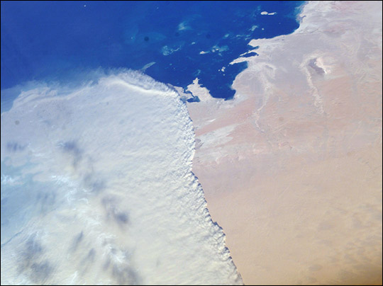 |
| Massive Sandstorm in Qatar: This striking photograph shows a massive sandstorm sweeping over the Persian Gulf state of Qatar as it races southward toward southeastern Saudi Arabia and the United Arab Emirates on February 15, 2004. A major upper level low pressure over southwestern Asia led to a series of storms sweeping through the area. The crew of the International Space Station acquired this image with a digital camera using a 50-mm lens. |
| Images: | All Available Images Low-Resolution 70k |
|
| Mission: | ISS008 |
|
| Roll - Frame: | E - 16355 |
|
| Geographical Name: | SAUDI ARABIA |
|
| Features: | SAND STORM FRONT, PERSIAN GULF COAST |
|
| Center Lat x Lon: | 24.0N x 51.0E |
|
| Film Exposure: | N=Normal exposure, U=Under exposed, O=Over exposed, F=out of Focus |
|
| Percentage of Cloud Cover-CLDP: | 50 |
|
| Camera:: | E4 |
|
| Camera Tilt: | 45 | LO=Low Oblique, HO=High Oblique, NV=Near Vertical |
| Camera Focal Length: | 50 |
|
| Nadir to Photo Center Direction: | N | The direction from the nadir to the center point, N=North, S=South, E=East, W=West |
| Stereo?: | Y=Yes there is an adjacent picture of the same area, N=No there isn't |
|
| Orbit Number: | 1907 |
|
| Date: | 20040215 | YYYYMMDD |
| Time: | 131112 | GMT HHMMSS |
| Nadir Lat: | 21.0N |
Latitude of suborbital point of spacecraft |
| Nadir Lon: | 49.8E |
Longitude of suborbital point of spacecraft |
| Sun Azimuth: | 248 | Clockwise angle in degrees from north to the sun measured at the nadir point |
| Space Craft Altitude: | 194 | nautical miles |
| Sun Elevation: | 19 | Angle in degrees between the horizon and the sun, measured at the nadir point |
| Land Views: | |
|
| Water Views: | GULF |
|
| Atmosphere Views: | |
|
| Man Made Views: | |
|
| City Views: | |
|
Photo is not associated with any sequences | ||
| NASA Home Page |
JSC Home Page |
JSC Digital Image Collection |
Earth Science & Remote Sensing |
|
This service is provided by the International Space Station program and the JSC Earth Science & Remote Sensing Unit, ARES Division, Exploration Integration Science Directorate.

|