
Geographic Region: IRAN
Feature: DUST STORM, KERMAN DESERT
|
Geographic Region: IRAN Feature: DUST STORM, KERMAN DESERT |
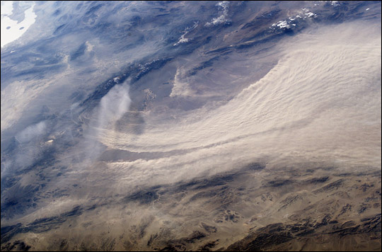 |
| Major Dust Storm East of Bam, Iran: This stunning photo shows a major dust storm raging in the Kerman Desert, just east of the city of Bam in Southeastern, Iran. The image was acquired by the crew of the International Space Station on the afternoon of February 15, 2004, using a digital camera with a 50-mm lens. |
| Images: | All Available Images Low-Resolution 88k |
|
| Mission: | ISS008 |
|
| Roll - Frame: | E - 16328 |
|
| Geographical Name: | IRAN |
|
| Features: | DUST STORM, KERMAN DESERT |
|
| Center Lat x Lon: | 29.0N x 59.0E |
|
| Film Exposure: | N=Normal exposure, U=Under exposed, O=Over exposed, F=out of Focus |
|
| Percentage of Cloud Cover-CLDP: | 50 |
|
| Camera:: | E4 |
|
| Camera Tilt: | HO | LO=Low Oblique, HO=High Oblique, NV=Near Vertical |
| Camera Focal Length: | 50 |
|
| Nadir to Photo Center Direction: | W | The direction from the nadir to the center point, N=North, S=South, E=East, W=West |
| Stereo?: | Y=Yes there is an adjacent picture of the same area, N=No there isn't |
|
| Orbit Number: | 1906 |
|
| Date: | 20040215 | YYYYMMDD |
| Time: | 113635 | GMT HHMMSS |
| Nadir Lat: | 29.1N |
Latitude of suborbital point of spacecraft |
| Nadir Lon: | 65.5E |
Longitude of suborbital point of spacecraft |
| Sun Azimuth: | 241 | Clockwise angle in degrees from north to the sun measured at the nadir point |
| Space Craft Altitude: | 194 | nautical miles |
| Sun Elevation: | 22 | Angle in degrees between the horizon and the sun, measured at the nadir point |
| Land Views: | DESERT |
|
| Water Views: | |
|
| Atmosphere Views: | DUST |
|
| Man Made Views: | |
|
| City Views: | |
|
Photo is not associated with any sequences | ||
| NASA Home Page |
JSC Home Page |
JSC Digital Image Collection |
Earth Science & Remote Sensing |
|
This service is provided by the International Space Station program and the JSC Earth Science & Remote Sensing Unit, ARES Division, Exploration Integration Science Directorate.

|