
Geographic Region: USA-TEXAS
Feature: EL PASO, CIUDAD JUAREZ, AIRPORT
|
Geographic Region: USA-TEXAS Feature: EL PASO, CIUDAD JUAREZ, AIRPORT |
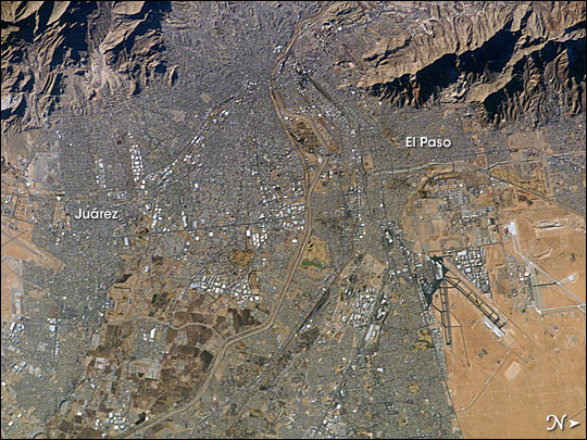 |
| This international image of the El Paso-Juarez area on the U.S.-Mexico border is the 100,000th photograph of Earth that astronauts have taken from the International Space Station. It was taken on January 26, 2004, by Expedition 8 crewmembers. The Rio Grande can be seen meandering through the area, forming the boundary between the sister cities of El Paso, Texas and Juarez, Chihuahua. North is to the right in this image, and the setting sun has cast the east side of the Sierra Juarez and Franklin Mountains into shadow. Photographs of Earth are a concrete way for astronauts to share their observations and experience in orbit with the public. Scientists integrate them with a variety of other remote sensing data in their Earth science research. The record of astronaut photography of Earth starts over 40 years ago with the first human spaceflights and represents the longest continuous record of the state of the planet as observed from orbit. |
| Images: | All Available Images Low-Resolution 97k |
|
| Mission: | ISS008 |
|
| Roll - Frame: | E - 13212 |
|
| Geographical Name: | USA-TEXAS |
|
| Features: | EL PASO, CIUDAD JUAREZ, AIRPORT |
|
| Center Lat x Lon: | 32.0N x 106.5W |
|
| Film Exposure: | N=Normal exposure, U=Under exposed, O=Over exposed, F=out of Focus |
|
| Percentage of Cloud Cover-CLDP: | 10 |
|
| Camera:: | E4 |
|
| Camera Tilt: | 23 | LO=Low Oblique, HO=High Oblique, NV=Near Vertical |
| Camera Focal Length: | 400 |
|
| Nadir to Photo Center Direction: | S | The direction from the nadir to the center point, N=North, S=South, E=East, W=West |
| Stereo?: | Y=Yes there is an adjacent picture of the same area, N=No there isn't |
|
| Orbit Number: | 1600 |
|
| Date: | 20040126 | YYYYMMDD |
| Time: | 224722 | GMT HHMMSS |
| Nadir Lat: | 33.4N |
Latitude of suborbital point of spacecraft |
| Nadir Lon: | 106.4W |
Longitude of suborbital point of spacecraft |
| Sun Azimuth: | 232 | Clockwise angle in degrees from north to the sun measured at the nadir point |
| Space Craft Altitude: | 195 | nautical miles |
| Sun Elevation: | 18 | Angle in degrees between the horizon and the sun, measured at the nadir point |
| Land Views: | |
|
| Water Views: | |
|
| Atmosphere Views: | |
|
| Man Made Views: | |
|
| City Views: | CHIHUAHUA, EL PASO |
|
Photo is not associated with any sequences | ||
| NASA Home Page |
JSC Home Page |
JSC Digital Image Collection |
Earth Science & Remote Sensing |
|
This service is provided by the International Space Station program and the JSC Earth Science & Remote Sensing Unit, ARES Division, Exploration Integration Science Directorate.

|