Geographic Region: ATLANTIC OCEAN
Feature: ICEBERG, SEA ICE FRAGMENTS
|
Geographic Region: ATLANTIC OCEAN Feature: ICEBERG, SEA ICE FRAGMENTS |
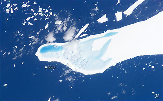 |
| Iceberg Melt, Near South Georgia: Astronauts on board the International Space Station took this detailed view of melt water pooled on the surface of iceberg A-39D, an iceberg measuring 2 km wide by 11 km long and currently drifting near South Georgia Island. The different intensities of blue are interpreted as different water depths. From the orientation of the iceberg, the deepest water (darkest blue) lies at the westernmost end of the iceberg. The water pools have formed from snowmelt--late January is the peak of summer in the Southern Hemisphere. This iceberg was part of the original A-38 iceberg (//nsidc.org/icebergs/a38/) that calved from the Ronne Ice Shelf in October 1998. Originally the ice was between 200 and 350 meters thick. This piece of that iceberg is now probably about 150 meters thick, with around 15 m sticking up above the surface of the water. This photograph was taken by astronauts looking south over the south Atlantic Ocean from the International Space Station on January 22, 2004. An accompanying oblique view, ISS008-E-12654, shows all three large remnant pieces of A-38 close to South Georgia Island. Based on the astronaut observations, Dr. Ted Scambos fo the National Snow and Ice Data Center decided to continue to track the icebergs. By April they had broken up, potentially as a result of the meltponding. |
| Images: | All Available Images Low-Resolution 45k |
|
| Mission: | ISS008 |
|
| Roll - Frame: | E - 12555 |
|
| Geographical Name: | ATLANTIC OCEAN |
|
| Features: | ICEBERG, SEA ICE FRAGMENTS |
|
| Center Lat x Lon: | 55S x 39W |
|
| Film Exposure: | N=Normal exposure, U=Under exposed, O=Over exposed, F=out of Focus |
|
| Percentage of Cloud Cover-CLDP: | 10 |
|
| Camera:: | E4 |
|
| Camera Tilt: | HO | LO=Low Oblique, HO=High Oblique, NV=Near Vertical |
| Camera Focal Length: | 400 |
|
| Nadir to Photo Center Direction: | SW | The direction from the nadir to the center point, N=North, S=South, E=East, W=West |
| Stereo?: | Y=Yes there is an adjacent picture of the same area, N=No there isn't |
|
| Orbit Number: | 1530 |
|
| Date: | 20040122 | YYYYMMDD |
| Time: | 123612 | GMT HHMMSS |
| Nadir Lat: | 50.9S |
Latitude of suborbital point of spacecraft |
| Nadir Lon: | 34W |
Longitude of suborbital point of spacecraft |
| Sun Azimuth: | 46 | Clockwise angle in degrees from north to the sun measured at the nadir point |
| Space Craft Altitude: | 205 | nautical miles |
| Sun Elevation: | 52 | Angle in degrees between the horizon and the sun, measured at the nadir point |
| Land Views: | ISLAND |
|
| Water Views: | ICE, OCEAN |
|
| Atmosphere Views: | |
|
| Man Made Views: | |
|
| City Views: | |
|
Photo is not associated with any sequences | ||
| NASA Home Page |
JSC Home Page |
JSC Digital Image Collection |
Earth Science & Remote Sensing |
|
This service is provided by the International Space Station program and the JSC Earth Science & Remote Sensing Unit, ARES Division, Exploration Integration Science Directorate.

|