Geographic Region: ARGENTINA
Feature: UPSALA GLACIER, CLOUDS
|
Geographic Region: ARGENTINA Feature: UPSALA GLACIER, CLOUDS |
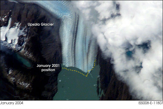 |
| Glacial Retreat: For the crew onboard the International Space Station daylight views of the Earth's Southern Hemisphere offer fewer opportunities to observe and document land features with onboard cameras. However, South America's Patagonian Ice Fields and glaciers in the far southern Andes mountains offer beautiful, dynamic features with frequent passes whenever weather conditions permit. On the afternoon of January 3, 2004, the crew took this view of the Upsala Glacier in Argentina through a 400mm lens. This is the third largest glacier of the Southern Patagonian Ice Field with an estimated area of over 800 square kilometers. This long, north-south oriented river of ice terminates in the northern arm of Lake Argentino. A worldwide retreat of glaciers was observed during the twentieth century and most of the Patagonia's glaciers, including Upsala were no exception. From the late 1960's to the mid 1990's the retreat of some parts was in excess of 4 kilometers. The glacier's retreat appears to be continuing during the Space Station era with visible changes along the terminus noted when compared with ISS001-E-5318 taken in December 2000. The crew continues to monitor most of the principal glaciers of Patagonia as science targets for Crew Earth Observations. For more information on the observed history of Patagonia's glaciers please see: Historic Fluctuations of Outlet Glaciers from the Patagonian Ice Fields. |
| Images: | All Available Images Low-Resolution 41k |
|
| Mission: | ISS008 |
|
| Roll - Frame: | E - 11807 |
|
| Geographical Name: | ARGENTINA |
|
| Features: | UPSALA GLACIER, CLOUDS |
|
| Center Lat x Lon: | 50S x 73W |
|
| Film Exposure: | N=Normal exposure, U=Under exposed, O=Over exposed, F=out of Focus |
|
| Percentage of Cloud Cover-CLDP: | 75 |
|
| Camera:: | E4 |
|
| Camera Tilt: | HO | LO=Low Oblique, HO=High Oblique, NV=Near Vertical |
| Camera Focal Length: | 400 |
|
| Nadir to Photo Center Direction: | SE | The direction from the nadir to the center point, N=North, S=South, E=East, W=West |
| Stereo?: | Y=Yes there is an adjacent picture of the same area, N=No there isn't |
|
| Orbit Number: | 1237 |
|
| Date: | 20040103 | YYYYMMDD |
| Time: | 194401 | GMT HHMMSS |
| Nadir Lat: | 46.2S |
Latitude of suborbital point of spacecraft |
| Nadir Lon: | 76.5W |
Longitude of suborbital point of spacecraft |
| Sun Azimuth: | 294 | Clockwise angle in degrees from north to the sun measured at the nadir point |
| Space Craft Altitude: | 202 | nautical miles |
| Sun Elevation: | 51 | Angle in degrees between the horizon and the sun, measured at the nadir point |
| Land Views: | GLACIER |
|
| Water Views: | ICE, LAKE, RIVER |
|
| Atmosphere Views: | |
|
| Man Made Views: | |
|
| City Views: | |
|
Photo is not associated with any sequences | ||
| NASA Home Page |
JSC Home Page |
JSC Digital Image Collection |
Earth Science & Remote Sensing |
|
This service is provided by the International Space Station program and the JSC Earth Science & Remote Sensing Unit, ARES Division, Exploration Integration Science Directorate.

|