
Geographic Region: USA-NEBRASKA
Feature: OMAHA, MISSOURI RIVER, COUNCIL BLUFFS
|
Geographic Region: USA-NEBRASKA Feature: OMAHA, MISSOURI RIVER, COUNCIL BLUFFS |
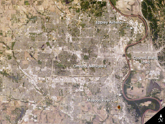 |
| The Missouri River served as a vital waterway for transport of the epic Lewis and Clark Expedition. In the vicinity of Omaha, Nebraska, and Council Bluffs, Iowa, this mighty river meanders southward through a broad floodplain some two to eight miles wide, bordered by dissected bluffs. In late July 1804, the expedition paused to rest and repair their boats and planned the "first" Native American council (Council Bluff) with representatives of the Otoe Tribe. This photograph was taken by the Expedition 7 crew of the International Space Station on June 13, 2003, and is among the first acquisitions of an ongoing effort to document from space dozens of historical sites along the Lewis and Clark Expedition's entire route. In this near-vertical view of Omaha--with a population estimated at more than three quarters of a million residents--the city is situated on high ground to the west of the river while Eppley Airfield and the town of Council Bluffs are located on the floodplain. |
| Images: | All Available Images Low-Resolution 76k |
|
| Mission: | ISS007 |
|
| Roll - Frame: | E - 7247 |
|
| Geographical Name: | USA-NEBRASKA |
|
| Features: | OMAHA, MISSOURI RIVER, COUNCIL BLUFFS |
|
| Center Lat x Lon: | 41.5N x 96W |
|
| Film Exposure: | N=Normal exposure, U=Under exposed, O=Over exposed, F=out of Focus |
|
| Percentage of Cloud Cover-CLDP: | 10 |
|
| Camera:: | E4 |
|
| Camera Tilt: | 22 | LO=Low Oblique, HO=High Oblique, NV=Near Vertical |
| Camera Focal Length: | 180 |
|
| Nadir to Photo Center Direction: | E | The direction from the nadir to the center point, N=North, S=South, E=East, W=West |
| Stereo?: | Y=Yes there is an adjacent picture of the same area, N=No there isn't |
|
| Orbit Number: | 2047 |
|
| Date: | 20030613 | YYYYMMDD |
| Time: | 182701 | GMT HHMMSS |
| Nadir Lat: | 41.2N |
Latitude of suborbital point of spacecraft |
| Nadir Lon: | 97.4W |
Longitude of suborbital point of spacecraft |
| Sun Azimuth: | 178 | Clockwise angle in degrees from north to the sun measured at the nadir point |
| Space Craft Altitude: | 209 | nautical miles |
| Sun Elevation: | 72 | Angle in degrees between the horizon and the sun, measured at the nadir point |
| Land Views: | |
|
| Water Views: | RIVER |
|
| Atmosphere Views: | |
|
| Man Made Views: | |
|
| City Views: | COUNCIL BLUFFS, OMAHA |
|
Photo is not associated with any sequences | ||
| NASA Home Page |
JSC Home Page |
JSC Digital Image Collection |
Earth Science & Remote Sensing |
|
This service is provided by the International Space Station program and the JSC Earth Science & Remote Sensing Unit, ARES Division, Exploration Integration Science Directorate.

|