 Photo #: ISS007-E-17770 Date: Oct. 2003
Geographic Region: USA-MASSACHUSETTS
Feature: BOSTON, AIRPORT, HARBOR, BAY

 Photo #: ISS007-E-17770 Date: Oct. 2003 Photo #: ISS007-E-17770 Date: Oct. 2003Geographic Region: USA-MASSACHUSETTS Feature: BOSTON, AIRPORT, HARBOR, BAY |
 |
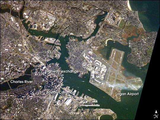
| Boston: Were astronauts cheering the Red Sox from the International Space Station? Or enjoying New England's fall colors on a fine fall day in mid October (the red color along the estuary north of Logan airport hints of the fall colors that the region enjoyed)? Or trying to observe Boston's "Big Dig", the local transportation project that is now the largest civil engineering project in U.S. history? Regardless of the reason, this image provides a good bird's-eye view of the center of the city, including famous colonial and independence locations extending from Boston Common to the North End. Wispy clouds hover over the south end of Logan Airport. Ship traffic in the Charles and Mystic Rivers is marked by the wakes of the ships. And highly reflective construction locations, including the new I-93 and bridge over the Charles River, and highway exchanges at Logan Airport mark new elements of Boston's Big Dig. |
| Images: | All Available Images Low-Resolution 92k |
|
| Mission: | ISS007 |
|
| Roll - Frame: | E - 17770 |
|
| Geographical Name: | USA-MASSACHUSETTS |
|
| Features: | BOSTON, AIRPORT, HARBOR, BAY |
|
| Center Lat x Lon: | 42.5N x 71W |
|
| Film Exposure: | N=Normal exposure, U=Under exposed, O=Over exposed, F=out of Focus |
|
| Percentage of Cloud Cover-CLDP: | 10 |
|
| Camera:: | E4 |
|
| Camera Tilt: | 14 | LO=Low Oblique, HO=High Oblique, NV=Near Vertical |
| Camera Focal Length: | 800 |
|
| Nadir to Photo Center Direction: | S | The direction from the nadir to the center point, N=North, S=South, E=East, W=West |
| Stereo?: | Y=Yes there is an adjacent picture of the same area, N=No there isn't |
|
| Orbit Number: | 59 |
|
| Date: | 20031020 | YYYYMMDD |
| Time: | 131352 | GMT HHMMSS |
| Nadir Lat: | 43.3N |
Latitude of suborbital point of spacecraft |
| Nadir Lon: | 70.7W |
Longitude of suborbital point of spacecraft |
| Sun Azimuth: | 128 | Clockwise angle in degrees from north to the sun measured at the nadir point |
| Space Craft Altitude: | 200 | nautical miles |
| Sun Elevation: | 21 | Angle in degrees between the horizon and the sun, measured at the nadir point |
| Land Views: | |
|
| Water Views: | ESTUARY, RIVER |
|
| Atmosphere Views: | |
|
| Man Made Views: | AIRPORT, BRIDGE, HIGHWAY |
|
| City Views: | BOSTON |
|
Photo is not associated with any sequences | ||
| NASA Home Page |
JSC Home Page |
JSC Digital Image Collection |
Earth Science & Remote Sensing |
|
|