
Geographic Region: USA-ILLINOIS
Feature: CHICAGO, LAKE MICHIGAN
|
Geographic Region: USA-ILLINOIS Feature: CHICAGO, LAKE MICHIGAN |
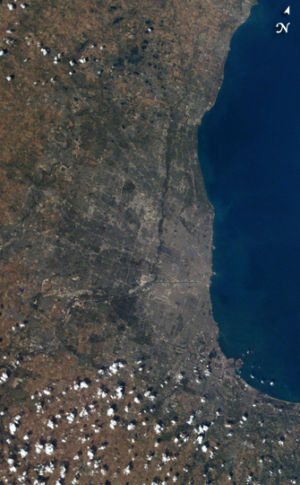 |
| Chicago by day. The population of the city of Chicago, IL is roughly 3 million people, but metropolitan Chicago includes nearly 10 million. This image stretches from East Chicago and Gary IND (bottom left) to Kenosha IL (right). The contrast between the gray urban region comprising metropolitan Chicago and the surrounding coastal plain is relatively unimpressive. |
| Images: | All Available Images Low-Resolution 256k |
|
| Mission: | ISS007 |
|
| Roll - Frame: | E - 16747 |
|
| Geographical Name: | USA-ILLINOIS |
|
| Features: | CHICAGO, LAKE MICHIGAN |
|
| Center Lat x Lon: | 42.0N x 88W |
|
| Film Exposure: | N=Normal exposure, U=Under exposed, O=Over exposed, F=out of Focus |
|
| Percentage of Cloud Cover-CLDP: | 25 |
|
| Camera:: | E4 |
|
| Camera Tilt: | 41 | LO=Low Oblique, HO=High Oblique, NV=Near Vertical |
| Camera Focal Length: | 50 |
|
| Nadir to Photo Center Direction: | NE | The direction from the nadir to the center point, N=North, S=South, E=East, W=West |
| Stereo?: | Y=Yes there is an adjacent picture of the same area, N=No there isn't |
|
| Orbit Number: | 3875 |
|
| Date: | 20031008 | YYYYMMDD |
| Time: | 184504 | GMT HHMMSS |
| Nadir Lat: | 39.6N |
Latitude of suborbital point of spacecraft |
| Nadir Lon: | 89.7W |
Longitude of suborbital point of spacecraft |
| Sun Azimuth: | 200 | Clockwise angle in degrees from north to the sun measured at the nadir point |
| Space Craft Altitude: | 201 | nautical miles |
| Sun Elevation: | 43 | Angle in degrees between the horizon and the sun, measured at the nadir point |
| Land Views: | PLAIN |
|
| Water Views: | |
|
| Atmosphere Views: | |
|
| Man Made Views: | |
|
| City Views: | CHICAGO, GARY |
|
Photo is not associated with any sequences | ||
| NASA Home Page |
JSC Home Page |
JSC Digital Image Collection |
Earth Science & Remote Sensing |
|
This service is provided by the International Space Station program and the JSC Earth Science & Remote Sensing Unit, ARES Division, Exploration Integration Science Directorate.

|