
Geographic Region: PERU
Feature: TOQUEPALA OPEN PIT MINE
|
Geographic Region: PERU Feature: TOQUEPALA OPEN PIT MINE |
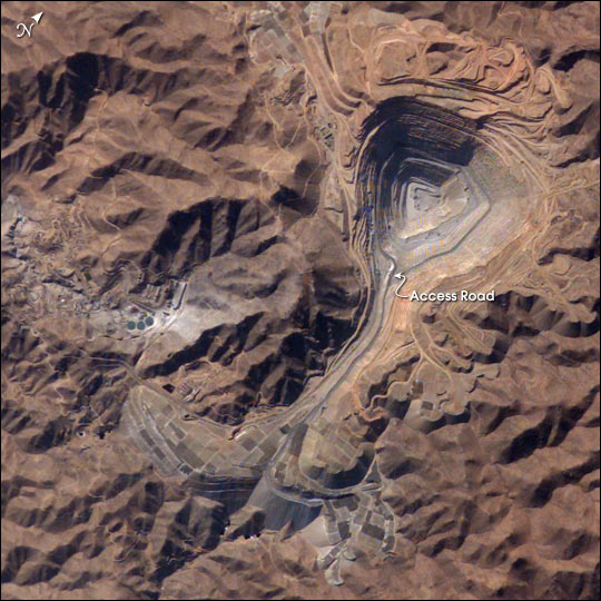 |
| Toquepala Copper Mine, Southern Peru: The rugged, mineral-rich Andes support some of the world's biggest mines (gold, silver, copper, and more). This image looks down the bull's-eye of Peru's Toquepala copper mine, a steep sided and stepped open-pit mine. Mid-afternoon sunlight on the arid slopes of the central Andes mountains provides an accent to the mine contours. At the surface the open pit is 6.5 km across and it descends more than 3000 m into the earth. A dark line on the wall of the pit is the main access road to the bottom. Spoil dumps of material mined from the pit are arranged in tiers along the northwest lip of the pit. Numerous angular leaching fields appear lower right, and the railroad to the coast is a line that exits the image center left. The railroad was built to export Toquepala's copper and connects the coastal port of Ilo, 95 km to the southwest. |
| Images: | All Available Images Low-Resolution 83k |
|
| Mission: | ISS007 |
|
| Roll - Frame: | E - 15222 |
|
| Geographical Name: | PERU |
|
| Features: | TOQUEPALA OPEN PIT MINE |
|
| Center Lat x Lon: | 17.5S x 70.5W |
|
| Film Exposure: | N=Normal exposure, U=Under exposed, O=Over exposed, F=out of Focus |
|
| Percentage of Cloud Cover-CLDP: | 10 |
|
| Camera:: | E4 |
|
| Camera Tilt: | 13 | LO=Low Oblique, HO=High Oblique, NV=Near Vertical |
| Camera Focal Length: | 400 |
|
| Nadir to Photo Center Direction: | NE | The direction from the nadir to the center point, N=North, S=South, E=East, W=West |
| Stereo?: | Y=Yes there is an adjacent picture of the same area, N=No there isn't |
|
| Orbit Number: | 3625 |
|
| Date: | 20030922 | YYYYMMDD |
| Time: | 201134 | GMT HHMMSS |
| Nadir Lat: | 18.2S |
Latitude of suborbital point of spacecraft |
| Nadir Lon: | 70.9W |
Longitude of suborbital point of spacecraft |
| Sun Azimuth: | 283 | Clockwise angle in degrees from north to the sun measured at the nadir point |
| Space Craft Altitude: | 206 | nautical miles |
| Sun Elevation: | 34 | Angle in degrees between the horizon and the sun, measured at the nadir point |
| Land Views: | |
|
| Water Views: | |
|
| Atmosphere Views: | |
|
| Man Made Views: | MINING |
|
| City Views: | |
|
Photo is not associated with any sequences | ||
| NASA Home Page |
JSC Home Page |
JSC Digital Image Collection |
Earth Science & Remote Sensing |
|
This service is provided by the International Space Station program and the JSC Earth Science & Remote Sensing Unit, ARES Division, Exploration Integration Science Directorate.

|