Geographic Region: BRAZIL
Feature: LENCOIS MARANHENSES, DUNES
|
Geographic Region: BRAZIL Feature: LENCOIS MARANHENSES, DUNES |
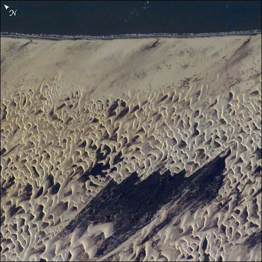 |
| The area shown here (10 km across) is a small part of the dune field which is now protected as the Lencois Maranhenses National Park, on Brazil's north coast, about 700 km east of the Amazon River mouth. Persistent winds blow off the equatorial Atlantic Ocean onto Brazil from the east, driving white sand inland from the 100 km stretch of coast (upper margin of the image), to form a large field of dunes. The strongly regular pattern of these dunes is a common characteristic of dune fields. The basic shape of each sand mass, repeated throughout the view, is a crescent-shaped dune. In an area with a rich supply of sand such as coastal Brazil, individual crescents coalesce to form entire chains many miles long. The wind strength and supply of sand are sufficient to keep the dunes active, and thus free of vegetation, despite 1500 mm (60 inches) of rainfall annually. The dark areas between the white dunes are fresh water ponds that draw fisherman to this newly established park. The characteristic regularity of the dune landscape can be detected downwind (west) for more than 100 km, beyond the present dune field. Now covered by dense forest, the greater extent of this dune field indicates that climates have been substantially drier at the Equator in the recent geological past. |
| Images: | All Available Images Low-Resolution 83k |
|
| Mission: | ISS007 |
|
| Roll - Frame: | E - 15177 |
|
| Geographical Name: | BRAZIL |
|
| Features: | LENCOIS MARANHENSES, DUNES |
|
| Center Lat x Lon: | 2.5S x 43W |
|
| Film Exposure: | N=Normal exposure, U=Under exposed, O=Over exposed, F=out of Focus |
|
| Percentage of Cloud Cover-CLDP: | 10 |
|
| Camera:: | E4 |
|
| Camera Tilt: | 22 | LO=Low Oblique, HO=High Oblique, NV=Near Vertical |
| Camera Focal Length: | 400 |
|
| Nadir to Photo Center Direction: | SE | The direction from the nadir to the center point, N=North, S=South, E=East, W=West |
| Stereo?: | Y=Yes there is an adjacent picture of the same area, N=No there isn't |
|
| Orbit Number: | 3609 |
|
| Date: | 20030921 | YYYYMMDD |
| Time: | 194325 | GMT HHMMSS |
| Nadir Lat: | 1.7S |
Latitude of suborbital point of spacecraft |
| Nadir Lon: | 44.1W |
Longitude of suborbital point of spacecraft |
| Sun Azimuth: | 271 | Clockwise angle in degrees from north to the sun measured at the nadir point |
| Space Craft Altitude: | 205 | nautical miles |
| Sun Elevation: | 16 | Angle in degrees between the horizon and the sun, measured at the nadir point |
| Land Views: | COAST, DUNE |
|
| Water Views: | OCEAN, RIVER |
|
| Atmosphere Views: | |
|
| Man Made Views: | |
|
| City Views: | |
|
Photo is not associated with any sequences | ||
| NASA Home Page |
JSC Home Page |
JSC Digital Image Collection |
Earth Science & Remote Sensing |
|
This service is provided by the International Space Station program and the JSC Earth Science & Remote Sensing Unit, ARES Division, Exploration Integration Science Directorate.

|