Geographic Region: ATLANTIC OCEAN
Feature: PAN-HURRICANE ISABEL, EYE
|
Geographic Region: ATLANTIC OCEAN Feature: PAN-HURRICANE ISABEL, EYE |
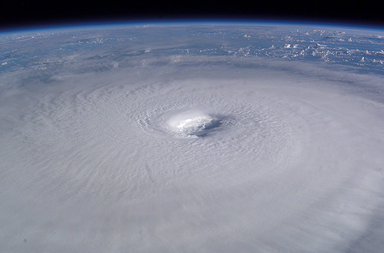 |
| Hurricane Isabel: Astronaut Ed Lu captured this broad-view photograph of Hurricane Isabel from the International Space Station on September 13, 2003, at 11:19 UTC. At the time, Isabel was located about 450 miles northeast of Puerto Rico and packed winds of 150 miles per hour with gusts up to 184 miles per hour. The image, ISS007-E-14750, was taken with a 50 mm lens on a digital camera. |
| Images: | All Available Images Low-Resolution 198k |
|
| Mission: | ISS007 |
|
| Roll - Frame: | E - 14750 |
|
| Geographical Name: | ATLANTIC OCEAN |
|
| Features: | PAN-HURRICANE ISABEL, EYE |
|
| Center Lat x Lon: | 22.5N x 62W |
|
| Film Exposure: | N=Normal exposure, U=Under exposed, O=Over exposed, F=out of Focus |
|
| Percentage of Cloud Cover-CLDP: | 10 |
|
| Camera:: | E4 |
|
| Camera Tilt: | HO | LO=Low Oblique, HO=High Oblique, NV=Near Vertical |
| Camera Focal Length: | 50 |
|
| Nadir to Photo Center Direction: | N | The direction from the nadir to the center point, N=North, S=South, E=East, W=West |
| Stereo?: | Y=Yes there is an adjacent picture of the same area, N=No there isn't |
|
| Orbit Number: | 3479 |
|
| Date: | 20030913 | YYYYMMDD |
| Time: | 111934 | GMT HHMMSS |
| Nadir Lat: | 15.2N |
Latitude of suborbital point of spacecraft |
| Nadir Lon: | 58.7W |
Longitude of suborbital point of spacecraft |
| Sun Azimuth: | 92 | Clockwise angle in degrees from north to the sun measured at the nadir point |
| Space Craft Altitude: | 204 | nautical miles |
| Sun Elevation: | 22 | Angle in degrees between the horizon and the sun, measured at the nadir point |
| Land Views: | |
|
| Water Views: | |
|
| Atmosphere Views: | HURRICANE |
|
| Man Made Views: | |
|
| City Views: | |
|
Photo is not associated with any sequences | ||
| NASA Home Page |
JSC Home Page |
JSC Digital Image Collection |
Earth Science & Remote Sensing |
|
This service is provided by the International Space Station program and the JSC Earth Science & Remote Sensing Unit, ARES Division, Exploration Integration Science Directorate.

|