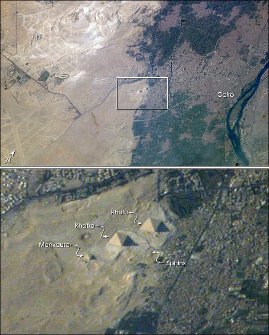
 Photo #: ISS007-E-12915 Date: Aug. 2003
Geographic Region: EGYPT
Feature: PYRAMIDS, GIZA, NILE RIVER, ROADS

 Photo #: ISS007-E-12915 Date: Aug. 2003 Photo #: ISS007-E-12915 Date: Aug. 2003Geographic Region: EGYPT Feature: PYRAMIDS, GIZA, NILE RIVER, ROADS |
 |
| As an example of the high resolution imagery achieved from the ISS, this view shows the Great pyramids of Egypt at approximately 6 m resolution. Although the pyramids have been imaged many times by astronauts, the specific combination of look angle, illumination from the sun, and weather conditions created a unique image. The sides of the pyramids face the cardinal directions, and the afternoon sun casts arrow-like shadows that point due East. The composition of the full photograph--including human developments that are thousands of years old adjacent to extensive new developments--piques the interest of the general public. These types of images are used extensively by educators and students in science, history, geography, political science, and math classes. ll astronauts are interested in observing unique human footprints from space, and especially those reflecting thousands of years of human activities. The region of the Great Pyramids of Giza--the last remaining wonder of the Seven Wonders of the Ancient World--is a favorite target. Although the pyramids have been imaged many times before by astronauts, each new image provides a unique look at the archeological monument, depending on the viewing angle from the ISS and the illumination from the sun. Giza is a royal burial place, commissioned and built by pharaohs during the fourth dynasty around 2550 BC. Started by Khufu, continued by his son Khafre (Khafre pyramid and the Sphinx), and later by his son, Menkaure, the complex also includes many tombs and temples for queens, other members of royal families, and royal attendants. The low sun angle in this image allows for many of the smaller surrounding monuments to be observed. Further, the sides of the pyramid align with the cardinal directions. In this view, the shadows from afternoon sun provide directional arrows that point east. For scale, the current length of the large pyramid at the base is 227 m (745 ft), and the height is 137 m (449). Today, Giza is a rapidly growing region of Cairo. Population growth in Egypt continues to soar, leading to new construction. New roads for large new developments are obvious in the desert hills northwest and southwest of the pyramids. Documenting patterns of urban growth around the world is a prime science objective for Earth photography by ISS astronauts. |
| Images: | All Available Images Low-Resolution 95k |
|
| Mission: | ISS007 |
|
| Roll - Frame: | E - 12915 |
|
| Geographical Name: | EGYPT |
|
| Features: | PYRAMIDS, GIZA, NILE RIVER, ROADS |
|
| Center Lat x Lon: | 30.0N x 31.0E |
|
| Film Exposure: | N=Normal exposure, U=Under exposed, O=Over exposed, F=out of Focus |
|
| Percentage of Cloud Cover-CLDP: | 10 |
|
| Camera:: | E4 |
|
| Camera Tilt: | 49 | LO=Low Oblique, HO=High Oblique, NV=Near Vertical |
| Camera Focal Length: | 800 |
|
| Nadir to Photo Center Direction: | SE | The direction from the nadir to the center point, N=North, S=South, E=East, W=West |
| Stereo?: | Y=Yes there is an adjacent picture of the same area, N=No there isn't |
|
| Orbit Number: | 3075 |
|
| Date: | 20030818 | YYYYMMDD |
| Time: | 145032 | GMT HHMMSS |
| Nadir Lat: | 31.8N |
Latitude of suborbital point of spacecraft |
| Nadir Lon: | 27.6E |
Longitude of suborbital point of spacecraft |
| Sun Azimuth: | 271 | Clockwise angle in degrees from north to the sun measured at the nadir point |
| Space Craft Altitude: | 202 | nautical miles |
| Sun Elevation: | 24 | Angle in degrees between the horizon and the sun, measured at the nadir point |
| Land Views: | DESERT |
|
| Water Views: | |
|
| Atmosphere Views: | |
|
| Man Made Views: | |
|
| City Views: | CAIRO |
|
Photo is not associated with any sequences | ||
| NASA Home Page |
JSC Home Page |
JSC Digital Image Collection |
Earth Science & Remote Sensing |
|
|