
Geographic Region: USA-TEXAS
Feature: AUSTIN, COLORADO RIVER, AIRPORT
|
Geographic Region: USA-TEXAS Feature: AUSTIN, COLORADO RIVER, AIRPORT |
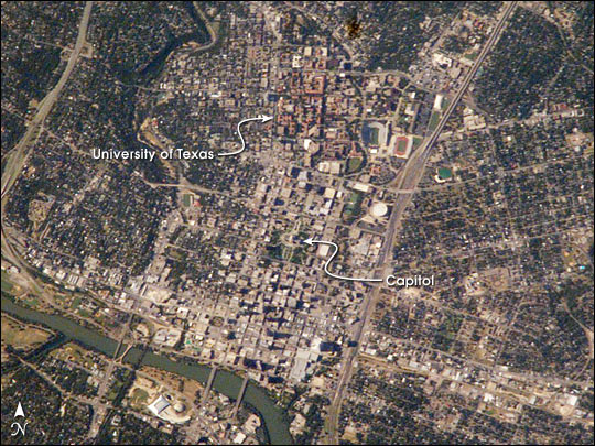 |
| It was Texas hot when this view of the capital city of Austin was taken in late July by astronaut Ed Lu. Adding to the rising temperatures were heated debates in the Texas Capitol Building, where a special session had convened. Eleven democratic senators thwarted a redistricting vote by disappearing from the state. Were Lu, and his Expedition 7 partner Yuri Malenchenko looking for the missing democratic senators? We'll never know, but they expanded their Austin search a week later with a wider view of Austin, taken with a 400 mm lens on August 6. Austin is an expanding city in the Texas hill country. A few decades ago Austin was known as a place where University of Texas students and state politicians co-existed along the banks of the Colorado River (seen snaking along the lower left of the image). Today, the exploding population (44% growth between 1990 and 2000) and increasing development stresses local resources like water, green space, and transportation networks, prompting city planners to think through scenarios for future development. Documenting city environments and city footprints over time is one of the science objectives of the Crew Earth Observations payload on the International Space Station. Astronauts have always enjoyed observing cities around the world. These images of Austin provide a 2003 baseline for monitoring its regional development and growth. |
| Images: | All Available Images Low-Resolution 101k |
|
| Mission: | ISS007 |
|
| Roll - Frame: | E - 11256 |
|
| Geographical Name: | USA-TEXAS |
|
| Features: | AUSTIN, COLORADO RIVER, AIRPORT |
|
| Center Lat x Lon: | 30.5N x 97.5W |
|
| Film Exposure: | N=Normal exposure, U=Under exposed, O=Over exposed, F=out of Focus |
|
| Percentage of Cloud Cover-CLDP: | 10 |
|
| Camera:: | E4 |
|
| Camera Tilt: | 38 | LO=Low Oblique, HO=High Oblique, NV=Near Vertical |
| Camera Focal Length: | 800 |
|
| Nadir to Photo Center Direction: | N | The direction from the nadir to the center point, N=North, S=South, E=East, W=West |
| Stereo?: | Y=Yes there is an adjacent picture of the same area, N=No there isn't |
|
| Orbit Number: | 2768 |
|
| Date: | 20030729 | YYYYMMDD |
| Time: | 224339 | GMT HHMMSS |
| Nadir Lat: | 28.0N |
Latitude of suborbital point of spacecraft |
| Nadir Lon: | 98.3W |
Longitude of suborbital point of spacecraft |
| Sun Azimuth: | 275 | Clockwise angle in degrees from north to the sun measured at the nadir point |
| Space Craft Altitude: | 204 | nautical miles |
| Sun Elevation: | 34 | Angle in degrees between the horizon and the sun, measured at the nadir point |
| Land Views: | |
|
| Water Views: | RIVER |
|
| Atmosphere Views: | |
|
| Man Made Views: | UNIVERSITY |
|
| City Views: | AUSTIN |
|
Photo is not associated with any sequences | ||
| NASA Home Page |
JSC Home Page |
JSC Digital Image Collection |
Earth Science & Remote Sensing |
|
This service is provided by the International Space Station program and the JSC Earth Science & Remote Sensing Unit, ARES Division, Exploration Integration Science Directorate.

|