 Photo #: ISS007-E-10974 Date: Jul. 2003
Geographic Region: ASIA
Feature: NOCTILUCENT CLOUDS, MOON
|
Photo #: ISS007-E-10974 Date: Jul. 2003 Geographic Region: ASIA Feature: NOCTILUCENT CLOUDS, MOON |
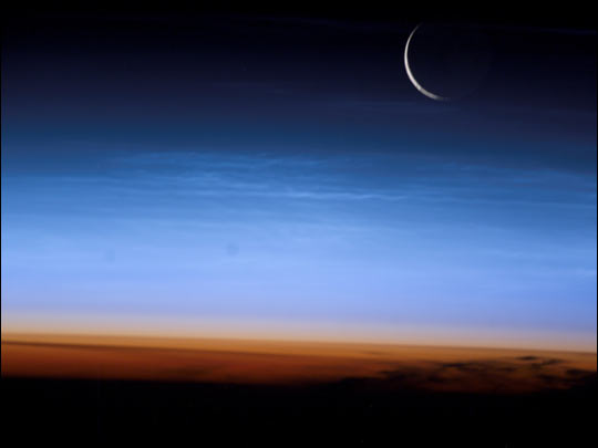 |
| The sliver of the setting moon and clouds that shine at night--noctilucent clouds--caught the eye of astronaut Ed Lu aboard the International Space Station (ISS) last week. Noctilucent clouds are very high clouds that look like cirrus clouds, but are much higher (75-90 km above the Earth's surface) than clouds that we observe every day. They are optically thin and can only be observed during twilight hours, when the sun is just below the horizon and only shines on the uppermost atmosphere. In this image, the limb of the Earth at the bottom transitions into the orange-colored troposphere, the lowest and most dense portion of the Earth's atmosphere. The troposphere ends abruptly at the tropopause, which appears in the image as the sharp boundary between the orange- and blue- colored atmosphere. The silvery-blue noctilucent clouds are far above this boundary. This image was taken July 27, 2003 when the ISS was over central Asia. June and July is the season for noctilucent clouds in the northern hemisphere--they form in the polar mesosphere, generally above 50 degrees latitude. Recent studies address why noctilucent clouds exist, whether the frequency of occurrence has increased throughout the 20th century (some researchers believe they have), and whether their frequency reflects human activities. Astronauts and cosmonauts have observed them over northern latitudes (Europe, Russia) in the past, but this summer's display has been remarkable. References: Zahn, U. , Are Noctilucent Clouds Truly a "Miner's Canary" for Global Change?, Eos, Vol. 84, No. 28, July 15, 2003 Related: //www.meteo.helsinki.fi/~tpnousia/nlcgal/nlcinfo.html //lasp.colorado.edu/noctilucent_clouds/ //www.u-net.com/ph/mas/observe/nlc/nlc.htm |
| Images: | All Available Images Low-Resolution 12k |
|
| Mission: | ISS007 |
|
| Roll - Frame: | E - 10974 |
|
| Geographical Name: | ASIA |
|
| Features: | NOCTILUCENT CLOUDS, MOON |
|
| Center Lat x Lon: | N x E |
|
| Film Exposure: | N=Normal exposure, U=Under exposed, O=Over exposed, F=out of Focus |
|
| Percentage of Cloud Cover-CLDP: | ||
| Camera:: | E4 |
|
| Camera Tilt: | HO | LO=Low Oblique, HO=High Oblique, NV=Near Vertical |
| Camera Focal Length: | 400 |
|
| Nadir to Photo Center Direction: | W | The direction from the nadir to the center point, N=North, S=South, E=East, W=West |
| Stereo?: | Y=Yes there is an adjacent picture of the same area, N=No there isn't |
|
| Orbit Number: | 2733 |
|
| Date: | 20030727 | YYYYMMDD |
| Time: | 171556 | GMT HHMMSS |
| Nadir Lat: | 46.5N |
Latitude of suborbital point of spacecraft |
| Nadir Lon: | 96.2E |
Longitude of suborbital point of spacecraft |
| Sun Azimuth: | 353 | Clockwise angle in degrees from north to the sun measured at the nadir point |
| Space Craft Altitude: | 203 | nautical miles |
| Sun Elevation: | -24 | Angle in degrees between the horizon and the sun, measured at the nadir point |
| Land Views: | MOON |
|
| Water Views: | |
|
| Atmosphere Views: | NOCTILUCENT CLOUDS |
|
| Man Made Views: | |
|
| City Views: | |
|
Photo is not associated with any sequences | ||
| NASA Home Page |
JSC Home Page |
JSC Digital Image Collection |
Earth Science & Remote Sensing |
|
This service is provided by the International Space Station program and the JSC Earth Science & Remote Sensing Unit, ARES Division, Exploration Integration Science Directorate.

|