
Geographic Region: BOLIVIA
Feature: RIO MAMORE, RIO ICHOA, MEANDERS
|
Geographic Region: BOLIVIA Feature: RIO MAMORE, RIO ICHOA, MEANDERS |
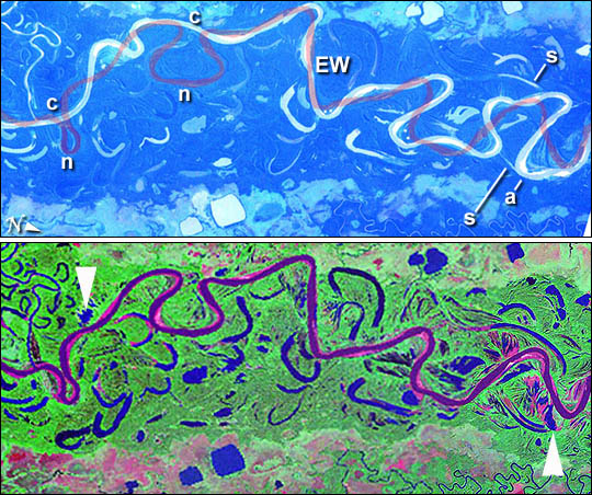 |
| The Mamore River drains north from the Andes Mts. in lowland Bolivia. An image taken in July 2003 from the International Space Station (ISS007-E-10797, 14 June 2003, 12:36 GMT) shows an 85 km stretch of the river south of the lowland town of Trinidad in the Beni Province. A 55-km stretch (centered at 15.2degS 66degW) was rectified to the commercially available 1990 edition of the Landsat TM imagery of the world. Numerous changes in river pattern are visible in the decade since the Landsat imagery was acquired. A pilot study was undertaken to characterize these rapid changes. Tie points were selected for geomorphic features which do not undergo short-term change- i. e. oxbow lakes and subsidence lakes in the floodplain. The ISS image was enhanced slightly to reveal the Mamore River channel. The ISS image (top) shows Mamore River meandering in a floodplain with numerous contorted channel traces indicating former positions of the river. The darker areas are riverine forest, the lighter areas tropical savanna. The river trace as it was in 1990 (bottom) is superimposed on the 2003 handheld image. Interpretation
|
| Images: | All Available Images Low-Resolution 117k |
|
| Mission: | ISS007 |
|
| Roll - Frame: | E - 10797 |
|
| Geographical Name: | BOLIVIA |
|
| Features: | RIO MAMORE, RIO ICHOA, MEANDERS |
|
| Center Lat x Lon: | 15S x 65W |
|
| Film Exposure: | N=Normal exposure, U=Under exposed, O=Over exposed, F=out of Focus |
|
| Percentage of Cloud Cover-CLDP: | 10 |
|
| Camera:: | E4 |
|
| Camera Tilt: | 34 | LO=Low Oblique, HO=High Oblique, NV=Near Vertical |
| Camera Focal Length: | 180 |
|
| Nadir to Photo Center Direction: | SW | The direction from the nadir to the center point, N=North, S=South, E=East, W=West |
| Stereo?: | Y=Yes there is an adjacent picture of the same area, N=No there isn't |
|
| Orbit Number: | 2672 |
|
| Date: | 20030723 | YYYYMMDD |
| Time: | 203027 | GMT HHMMSS |
| Nadir Lat: | 13.1S |
Latitude of suborbital point of spacecraft |
| Nadir Lon: | 63.6W |
Longitude of suborbital point of spacecraft |
| Sun Azimuth: | 297 | Clockwise angle in degrees from north to the sun measured at the nadir point |
| Space Craft Altitude: | 208 | nautical miles |
| Sun Elevation: | 20 | Angle in degrees between the horizon and the sun, measured at the nadir point |
| Land Views: | FOREST, VALLEY |
|
| Water Views: | CHANNEL, RIVER |
|
| Atmosphere Views: | |
|
| Man Made Views: | |
|
| City Views: | |
|
Photo is not associated with any sequences | ||
| NASA Home Page |
JSC Home Page |
JSC Digital Image Collection |
Earth Science & Remote Sensing |
|
This service is provided by the International Space Station program and the JSC Earth Science & Remote Sensing Unit, ARES Division, Exploration Integration Science Directorate.

|