
Geographic Region: USA-CALIFORNIA
Feature: LOS ANGELES AT NIGHT
|
Geographic Region: USA-CALIFORNIA Feature: LOS ANGELES AT NIGHT |
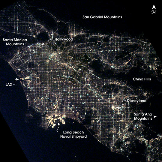 |
| After sunset the borders of "The City of Angels" are defined as much by its dark terrain features as by its well-lit grid of streets and freeways. Over 13 million people inhabit the coastal basin bounded roughly by the Santa Monica and San Gabriel Mountains to the north and the Chino Hills and Santa Ana Mountains to the east and southeast. The crew of the International Space Station took this unique image shortly after 1 a.m. local time on March 10, 2003. Both the glitter and sprawl of America's second largest city as well as a number of its renowned landmarks are highly visible. In the north, Hollywood is nestled against the south side of the Santa Monica Mountains. On the coast, Los Angeles International Airport (LAX) and the port facilities at Long Beach Naval Shipyards are bright spots. Finally, even at this time of night, the bright lights of Disneyland in Anaheim are a standout feature. |
| Images: | All Available Images Low-Resolution 90k |
|
| Mission: | ISS006 |
|
| Roll - Frame: | E - 36913 |
|
| Geographical Name: | USA-CALIFORNIA |
|
| Features: | LOS ANGELES AT NIGHT |
|
| Center Lat x Lon: | 34.0N x 118W |
|
| Film Exposure: | N=Normal exposure, U=Under exposed, O=Over exposed, F=out of Focus |
|
| Percentage of Cloud Cover-CLDP: | 10 |
|
| Camera:: | E4 |
|
| Camera Tilt: | 33 | LO=Low Oblique, HO=High Oblique, NV=Near Vertical |
| Camera Focal Length: | 85 |
|
| Nadir to Photo Center Direction: | SW | The direction from the nadir to the center point, N=North, S=South, E=East, W=West |
| Stereo?: | Y=Yes there is an adjacent picture of the same area, N=No there isn't |
|
| Orbit Number: | 559 |
|
| Date: | 20030310 | YYYYMMDD |
| Time: | 091507 | GMT HHMMSS |
| Nadir Lat: | 35.3N |
Latitude of suborbital point of spacecraft |
| Nadir Lon: | 116.1W |
Longitude of suborbital point of spacecraft |
| Sun Azimuth: | 36 | Clockwise angle in degrees from north to the sun measured at the nadir point |
| Space Craft Altitude: | 209 | nautical miles |
| Sun Elevation: | -54 | Angle in degrees between the horizon and the sun, measured at the nadir point |
| Land Views: | BASIN, COAST |
|
| Water Views: | |
|
| Atmosphere Views: | |
|
| Man Made Views: | AIRPORT |
|
| City Views: | LOS ANGELES, SANTA MONICA |
|
Photo is not associated with any sequences | ||
| NASA Home Page |
JSC Home Page |
JSC Digital Image Collection |
Earth Science & Remote Sensing |
|
This service is provided by the International Space Station program and the JSC Earth Science & Remote Sensing Unit, ARES Division, Exploration Integration Science Directorate.

|